Report on the irrigation investigation |
Up: Documents List Previous: Hudson Reservoir and Canal Company Next: Conditions and Cost of Water Storage
|
Source: 54TH CONGRESS, SENATE. DOCUMENT No. 27. REPORT ON DECEMBER 16, 1896.Presented by Mr. ALLEN, referred to the Committee on Indian Affairs, and ordered to be printed. WASHINGTON: DEPARTMENT OF THE
INTERIOR, SIR: I beg to transmit the report by Mr. Arthur P. Davis on the investigation of the water supply for the Gila River Indian Reservation, Ariz. The occasion of this investigation lies in the necessity of promptly providing water for use in the agriculture on this reservation. The Indians here located have from time immemorial been self-supporting. They have carried on irrigation for centuries by means of water taken from Gila River. This river, however, derives its supply from remote regions and flows for several hundred miles through arid lands susceptible of a high degree of cultivation by irrigation. The amount of water flowing in the river is, moreover, far less than that needed to supply the fertile lands along its course. For a number of years the United States has been and still is rapidly disposing of the land along the river, it being well known that these lands have no value unless water is taken from the stream, and it has been equally apparent that by this action the Indians would be pauperized by being deprived of their only means of support. Public attention has been called to this matter from time to time, and a considerable body of correspondence exists, the accumulated papers being referred backward and forward from bureau to bureau for the past decade, but no solution of the question has been reached. Meanwhile it is asserted that the Indians, learning to depend upon the Government for food and clothing, have been readily losing their capabilities for self-support and are becoming a permanent charge and source of annual expense. If they are to be kept from further degradation it is necessary that prompt action be taken toward enabling them to practice some means of self-support. This is possible only by securing to them the means of obtaining an ample supply of water. In the report herewith transmitted Mr. Davis discusses various means of obtaining water, suggested in the course of the long preliminary correspondence and by careful examination of the ground. The first and most obvious is that of compelling the white man to turn back into the river an amount of water equal to that formerly employed by the Indians. This is in line with the prevailing doctrine of priority of right, and would seem at first glance to be the simplest solution. Further consideration, however, shows that it is impracticable. The Government has taken no steps to protect the prior claims of the Indians to the water, and, on the other hand, has acquiesced in its diversion to the lands which it has disposed of to other parties all along the stream. These lands have passed from one holder to another, and it would be the height of injustice to deprive the present occupants of the water which they have been using for many years and without which their property would become worthless. Such a course, too, would be opposed to the common-sense view of the question, in that, in order to irrigate 1 acre on the reservation, enough water must be kept in the upper course of the stream to irrigate several acres, the loss from evaporation and seepage being extremely great as the water slowly finds its way across scores miles of arid plain. Several acres well tilled by white men would thus be destroyed for the benefit of 1 acre poorly worked by the Indians. The next question which is suggested is whether water can not be had on the reservation itself by means of wells, possibly artesian in character. Wells of this character do not, as a rule, furnish sufficient water to be of relatively great importance to irrigation. Were it possible to obtain wells similar to some of those in the Dakotas, Texas, or California, water might be had at cost which, though large, would not be prohibitory. There are, however, few reasons to hope for the successful construction of wells delivering a large quantity of water sufficiently sweet for use in agriculture. On this point, however, there is necessity for a careful study of the geologic structure of the region. This can be made only by the expenditure of considerable time and money-more than was available for the investigation completed by Mr. Davis. On the lower lands of the reservation wells obtain water which is apparently seeping slowly in the general direction of the stream. The proposition has been made that by means of a submerged dam or a water-tight wall placed beneath the surface across the valley and extending down to bed rock this seeping water would be held back and forced to the surface, where it could be diverted for irrigation. This scheme is based upon assumption as to the quantity of water and rate of flow which have nowhere been shown to exit. The amount money required to construct such a submerged dam and make the experiment is so enormously large in comparison with the probable benefits, that the project may be dismissed as chimerical. The water found by the wells which reach this underground supply can, however, be brought to the surface by various forms of pumping machinery. This method is one susceptible of more definite discussion, and its practicability rests more clearly upon consideration of cost and value of the results. Mr. Davis has shown that moderate amounts of water can be obtained from these wells, and has made as careful estimates as his opportunities permitted of the cost of installing pumping plants. He has shown that the first cost is not relatively great, but that the consumption of fuel and the annual maintenance will be so large that, all things considered, this is not ultimately the most economical. For small pumping plants sufficient to cover 200 acres of land the first cost will be about $5,000 or $25 per acre, and the annual cost $1,000 or $5 per acre cultivated. The purchase of water from some corporation has been urged as a solution of the difficulty. Although the low-water flow of Gila River is fully used, yet there are possibilities of storing the floods of it and of its large tributary, Salt River. A number of projects have been entered upon by promoters and capitalists, having in view the construction of large dams to furnish an additional supply to canals now covering more land than can be properly irrigated. The chief difficulty here lies in the impracticability, proved by past experience, of the Government entering into a partnership or becoming a tenant of any corporation. In this case the difficulty is aggravated by the fact that none of these projects are actually complete, and their achievement depends, to a certain extent, upon the share that the Government may take in the construction. It has been proposed to facilitate that raising of capital for these storage projects by the grant of a considerable body of land, but, as shown by Mr. Davis, it would be preferable as a business proposition for the Government to do all the work and dispose of the benefited land, keeping the increased value to repay the cost of the project. The Government, not having exclusive control of the reservoir, would not be sure of the successful completion or of proper maintenance. The matter of the construction of a reservoir to hold flood waters for use on the reservation has been most carefully considered by Mr. Davis. He has made a through survey of the most obvious site, that at The Buttes, 25 miles above the reservation. The careful survey shows that a dam reaching a height of 160 feet above the bed of the river will impound very nearly 208,000 acre-feet. Unfortunately, at this point the depth to bed rock is considerable, necessitating the construction of a dam 235 feet in height of above the solid rock. The total cost of a masonry dam at this point, including probable damages to private property, will be, in round numbers, $2,244,000, or less than $30 per acre for the land which can irrigated. The annual cost of maintenance is estimated to be not more than $15,000, or, in the round numbers, 20 cents per year per acre covered. The report discusses at some length the supply available for this reservoir, the probability of its being in time reduced in capacity by slit, and the possibility of removing a portion of this slit by hydraulic works. The capacity of this reservoir will be, of course, largely in excess of the needs of the Indians, and it has been shown that this extra water can probably be sold with the land at a cost sufficient to defray the greater part of the expense of construction. In the course of this investigation a smaller reservoir site was examined to the north, on what is known as Queen Creek, an intermittent stream down whose channel a considerable amount of flood water pours at irregular intervals. For this locality it was deemed most desirable to use a rock-filled dam with an apron on the upstream side, consisting of a pavement of asphalt concrete. A dam 115 feet in height above the bed of the creek will hold over 27,000 acre-feet. Of this amount it is estimated that fair reliance can be placed upon an annual use of 10,000 acre-feet, the balance being held for future use and to replace the loss by evaporation. The estimated cost will be $221,000, or about $35 per acre for the land actually watered, this being considerably higher per acre than for the reservoir at the Buttes, but the first cost being notably less. Mr. Davis has shown that the water held by a structure at this place can, however, be employed to better advantage on lands nearer to the reservoir, instead of being carried down to the reservation. This report brings matters to the point where some decisive step must be taken unless the policy of procrastination is to be continued. The facts are now before the Department and can be presented to Congress with recommendations through the proper channels. It is highly important, however, that the observations of river flow be maintained through a considerable period, in order that more reliable estimates may be made of the amount of water available for storage. These observations should be maintained continuously up to the time a final decision is reached or until construction is begun at one or both of the reservoir sites.
Very respectfully,
Hon. CHARLES D.
WALCOTT, REPORT ON THE IRRIGATION INVESTIGATION FOR THE BENEFIT OF THE PIMA AND OTHER INDIANS ON THE GILA RIVER INDIAN RESERVATION, ARIZONA. WASHINGTON, D. C., November 10, 1896. SIR: By your letter of November 25, 1895, I was authorized and directed to proceed from Washington, D. C., to Florence, Ariz., and from there to other points in the Territory of Arizona, for the purpose of making an investigation for a water supply for the Gila Indian Reservation, this work being carried on under the allotment of $3,500 from the amount appropriated by the Indian appropriation act of March 2, 1895, according to the designation made by letter of November 8 by the honorable the Secretary of the Interior. In accordance with these instructions I started for Arizona on the 29th day of November, 1895. The work contemplated requiring the equipment of field parties, four animals, together with wagons and a quantity of camp material, the property of the United States Geological Survey, were shipped from Los Angeles, Cal., to Casa Grande, Ariz., for use upon this work. As soon as practicable, measurements of the flow of the Gila River were begun at a point about 14 miles east of Florence, where the river passes through a narrow gorge known as The Buttes. Mr. Cyrus C. Babb, assistant hydrographer, was detailed to assist in the work, and reported for duty January 1, 1896. The various investigations required by this assignment were taken up as circumstances permitted and conditions became favorable, and in order to make this report more connected, the investigation and results will be reported by topics rather than in chronological order. The problem under investigation is well stated in the following extract from a letter to the honorable the Secretary of the Interior from the Acting Commissioner of Indian Affairs, dated January 5, 1891: The matter of the diversion of the accustomed water supply for the Pima Reservation appears to have been before this office and the Department for the last four or five years. In a report dated March 1, 1886, Commissioner Atkins invited the attention of the Department to a letter from Agent Wheeler Stating that there was a project on foot to take the water form the Gila River at a point about 12 miles above the town of Florence, by means of an irrigating canal, in such quantities as would practically destroy the farms of the Pima and Maricopa Indians living on the river, from a point a little below Florence to its junction with Salt River, and that the effect would be to render the Pimas helpless and destitute, the water being absolutely necessary to their existence. It was suggested that the subject be referred to the Attorney-General with the request that the United States attorney for Arizona be instructed to take such steps under the Federal or Territorial law as might be necessary to protect the Indians in their rights. March 2, 1886, the subject was referred by the Department to the Attorney-General, who directed the United States attorney for Arizona to take the necessary steps to protect the said Indians from the effects of the projected canal. His report was received by this Department with letter from the Attorney-General of June 4, 1886. From his report it appeared that a stock company had been organized for the construction of a canal with a capital of $1,000,000. He was unable to state, however, what effect a canal or dam would have on the river below, and suggested that as the dam would not be constructed before October, 1886, suit should not be brought until more facts had been obtained by some one charged specially with the matter. July 14, 1886, this office again brought the matter to the attention of the Department, recommending that the Director of the Geological Survey be instructed to detail a competent man from that Bureau to investigate and report to the Department whether the effect of the proposed canal would be likely to prove disastrous to the Indians, and whether the canal company could and would construct suitable ditches and connect the canal with the reservation and supply the Indians with sufficient of water. The investigation suggested was made by the Geological Survey, as a result of with the following facts were established:
The result of this investigation was communicated to the Government June 11, 1887, with the recommendation that the subject be again referred to the Attorney-General with request that the United States district attorney be directed to take the necessary steps to enjoin the said canal company form any diversion of the waters of the Gila River to the injury of the Indians on the Pima and Maricopa reservation, or to take such other steps as might be deemed advisable to protect the Indians in the continued enjoyment of their rights. In office report of August 6, 1887, the attention of the Department was invited to previous correspondence relative to this matter, and advised that the Florence Canal Company, by its president, in order to avoid litigation, had promised to enter into such stipulations as the Government might propose, not to diminish the quantity of water used by the Indians, and asked that the United States attorney be instructed to stay proceedings for a reasonable time to allow said company to enter into such engagement. The Acting Commissioner stated that he regarded the matter as practically out of the hands of this Department, the United States attorney having been instructed to apply for an injunction restraining the company form diverting the water to the injury of the Indians, or to take such other steps as he might deem advisable to protect them, and added that if in the judgement of the district attorney, in whole hands the matter rested, it would be safe and proper to enter into the proposed agreement, he entertained no doubt that the district attorney would arrange the details in a manner satisfactory to this Department. December 30, 1887, this office received by reference from the Department a copy of a report from the United States attorney for Arizona, transmitting a copy of the resolution of the Florence Canal Company, binding said company and its successors and assigns not to use and operate this canal in such manner as to deprive the Indians on the Pima Reservation of any of their existing rights in the waters of the Gila River for irrigation purposes, and that in case it should be found that the diversions of water from said river by means of a canal materially lessened at low stages of water the then present supply of the Indians, then in that event said company binds itself to remedy the evil either by closing the head gate of their canal or by allowing then Indians to take water from canal at a point nearest the reservation. The papers were submitted by the Attorney-General for consideration and such suggestions as this Department might deem best. April 11, 1888, the Commissioner referred to his letter of August 6, 1887, and stated that if the agreement should finally be accepted he would endeavor to procure the services of an army engineer officer to make such measurements as the attorney might require to determine the quantity of water then used by the Indians in irrigating their farms if he were advised of the desire of the desire of the district attorney to have such measurements made. October 23, 1890, the Acting Commissioner invited the attention of the Department to said office letter of April 11, 1888, and recommended that the Attorney-General be requested to advice this Department what action, if any, had been taken to protect the rights of said Indians against the said canal company. This information was requested in view of the fact that the agent at the Pima Agency had reported that if the canal company were permitted to have full control of the reservoir in connection with the canal, he feared the Indians need expect no benefit therefrom. No reply to this communication has been received. It appears from foregoing that this matter has been for some years and is still in the proper hands of law officers of the Government. The right of the Indians to the quantity of water which they have been accustomed to obtaining from the Gila River for irrigating and domestic purposes would seem to be beyond discussion. I think it would be well to call the attention of the Department of Justice to previous correspondence on the subject, and to request that the proper and necessary steps be at once taken to secure the rights of the Indians. I also have the honor to request that this office to be advised as to the present status of the case, and of the final result of the action taken by the Department of Justice. R. V. BELT, Acting Commissioner. A latter status of the case is given in the following letter to the Commissioner of Indian Affairs from the United States Indian agent at Sacaton, Ariz.: UNITED STATES INDIAN
SERVICE, PIMA AGENCY, SIR: I have the honor to again refer to the question of water for the Indians of the Gila River Reservation of this agency. The supply allowed to pass by the Florence and other canal companies and owners of irrigation ditches and reservoir on the upper river is now entirely exhausted except at points where the sunken waters of the river are forced to the surface by natural dams. At such points the crops are good, but from present observations and reports I am forced to believe that a large number of these Indians will have to be fed during the coming winter. They have made a strong effort to make a crop and would have done so had the water supply not given out, and it did so earlier this year by thirty days than it did last year, when they had water until May 1, while they have been without this year since April 10. These Indians, as your office is well aware, were self-supporting practically until a few years ago, and would be so to-day if their water supply had been protected for them. Them building of dams and reservoirs and the extension of canals and ditches by the various canal companies along the river above the reservation, together with the increase of settlers and consequent increase in the supply of water required for their use, have all seemed to conspire against the prosperity, in fact the living, of these Indians. There is an especial increase to be noticed in the last year in the amount of water taken out on the upper Gila by the Mormon settlement above the Fort Thomas Military Reservation, and the opening of the Fort Thomas Military Reservation will add to it in the next year. Every inch of water taken out above the reservation results in a corresponding loss to the Indians. Since my return from the East I have taken particular pains, and availed myself of every possible opportunity to discuss this question with men who are posted on such matters, among the number being several civil engineers of reputation and experience. This has resulted in only a mass of theory and talk, and no remedy adequate to the necessities of the case has been suggested which did not involve the expenditure of a very large sum of money. Such an expenditure I am not prepared to recommend until the ground, conditions, and in fact everything connected with this matter have been scientifically examined by an engineer of ability and reputation, and a report made thereon. The whole matter sifted down in this: Either the Government will have to feed the majority of the Indians of the Gila River reservation-and the number of those requiring food will increase with each succeeding year-or they must be furnished with a supply of water sufficient to enable them to raise crops and support themselves. The question then arises as to how this supply of water is to be obtained, and on it there is a great diversity of opinion. Of the several methods which have been proposed to me I submit the following:
Such is the condition and some of the remedies proposed. What is best to be done I do not know. I recommend, however, that a competent, through, and skillful engineer, will acquainted with irrigation questions, be employed to ascertain and report, first, whether or not under existing conditions a supply of water adequate to the needs of these Indians can be obtained and retained permanently, and then, if such a supply can be obtained, what is the best, most feasible, practicable, and economical method of doing so. To properly do this, the engineer should examine carefully the past and present condition and flow of the Gila River, the amount of water which formerly passed through this reservation, and the amount we are now receiving; the number and amount of inched of water for which charters for ditches have been granted in the different countries through which the Gila flows, and the amount of water taken out under these charters, together with the number of such charters as are now legally in force; the underground currents and rock strata along the river, and all matters which, taken together, may lead to some solution of this question. I have been unable to get an estimate of what amount such an investigation and report will cost, but I would suggest that the sum of $5,000 be set apart from any appropriation available for this purpose. Competent and first-class engineers with ability to make such a report as this case requires are scarce and high priced, and will have to be well paid. It would be money thrown away to employ a man not thoroughly posted. This matter should be taken up soon, in order that we may know what to expect for next year.
Very respectfully, your obedient servant,
J. ROE YOUNG, Hon.D. M. BROWNING, Commissioner of Indian Affairs, Washington. The actual amount of water that it is necessary to provide depends upon (1) the number of Indians requiring water supply; (2) the amount of land required for the sustenance of each Indian;(3) the duty of water - that is, the amount of water required to irrigate an acre of land. Mr. J. Roe Young, the Indian agent at Sacaton, estimates that there are about 2,500 Indians on the reservation who now get very little water, and about 600 who have none at all. Assuming that the 2,500 mentioned obtain two-fifths of a supply of water, or that a supply for 1,500 inhabitants would meet their wants, this, in addition to those now destitute of water, calls for a supply for 2,100 Indians. In addition to these are about 2,000 wandering Papagoes who are continually committing depredations on the white settlers, and whom the Department desires to locate upon this reservation as soon as a water supply can be furnished. It may safely be assumed that the present urgent requirements are for a supply sufficient for 4,000 Indians. It may be assumed that these Indians will require about and acre and a half of ground per capita, or a total of 6,000 acres of irrigated land. Experience in Salt River Valley has shown that about 11/2 acre-feet of water is necessary to irrigate an acre of wheat or barley in one season. Alfalfa and other crops of longer season than grain require more water. The Indians will doubtless devote themselves chiefly to grain raising, with alfalfa, vegetables, and fruits as subordinate crops. It is approximately correct to adopt 10,000 acre-feet as the minimum supply that will meet present urgent needs on the Pima Reservation. As these Indians increase in number, and especially as they become more civilized, so as to cultivate more largely the crops of long season, such as fruits and alfalfa, and to tend a greater acreage, their requirements will increase, so that to permanently dispose of the problem, a supply of at least 20,000 acre-feet ought to be provided. The fact that the waters of the Indian reservation have been materially decreased by the construction of the Florence Canal is unquestioned. This having been permitted, the solution of the problem for a time seemed to depend upon legal action to prevent the diversion of the waters by this canal. Subsequent events, however, have altered the aspect of the question, from the fact that the supply of the Florence Canal itself is no short, owing to diversions for irrigation far above that point, chiefly in Graham and Cochise countries, Ariz. A broad view of the subject led to the conclusion that under present conditions it was not wise to devote any large portion of the funds allotted for this work to the investigation of the quantities and the legal status of diversions form the river above the reservation, for the following reasons:
It may be said that the users of water above the reservation have brought these hardships upon themselves by diverting waters to which the Indians held claim. This argument might apply to some extent to the companies who constructed the canals in the first place, but does not apply to the settlers who are in the position of innocent third parties, and who would be the real sufferers. The extent, however, to which even the original diverters of the Gila waters above the Indian Reservation are chargeable with blame is indefinite. The United States Government itself must shoulder a share of the responsibility for the present condition of things. It has permitted to an enormous extent and received money for the entry of desert lands along the valley of the Gila which could not possibly be of any value except by the use of the very water in question. This is the Government land policy throughout the arid region, and is productive of an immense amount of litigation, acrimony, pecuniary loss, and actual suffering. The present case is merely one in which the Government itself is one of the parties to the litigation and the pecuniary loss. The letter of Agent Young above quoted suggests numerous possibilities for a water supply for these Indians. Several other methods were suggested by an observation of the country, and it was early recognized that the time and money available for this inquiry were both far short of being sufficient for an exhaustive examination of all the hydrographic possibilities of the region. It became necessary, therefore, to eliminate such investigations as seemed to be impracticable under the conditions named, or to give least promise of proving the best means of obtaining the required supply, and to devote the available means, first, to the investigation of such sources of supply as seemed to promise the most feasible solution of the problem, and then, if any funds remained, to an inquiry into sources of secondary promise. This policy was adopted. The investigation of artesian possibilities was not attempted for the following reasons: There are two methods by which artesian conditions might be determined: First by experiment. The cost of a single artesian will in this country, to the depth which it would probably be necessary to go to obtain artesian water, would absorb nearly or quite all of the funds available for this work, and was therefore prohibitory. Second, by an extended topographic and geologic investigation of this part of Arizona, which, both in time and cost, was far beyond the reach of this inquiry. Even though it might be shown by either of these methods that artesian water was obtainable, there would then be no conclusive evidence that it could be obtained in sufficient quantity graphic and climatic conditions in Arizona is very strongly against any such supply being obtained, and experience in other parts of Arizona emphasizes this conclusion. The evidence is abundant that in comparison with other possibilities this method gives little promise of being a practicable solution of the problem. (1) There is no probability of there being any such volume of water flowing in the bed of the Gila River> as many seem to suppose. At The Buttes the Gila River is confined between bluffs 300 or 400 feet apart, with a bed of sand and gravel from 40 to 60 feet deep. Three miles below The Buttes bedrock crops out nearly the whole way across the stream, and is nowhere more than 10 or 15 feet below the surface. Necessarily most of the supposed underflow would come to the surface at this point, yet measurements show an actual loss between the Buttes and this point, due to evaporation from the river bed and adjacent sands. It is true that at two or three points on and near the reservation water appears in the Gila River, although the river is dry above these points. It by no means follows, however, that this water flows for any considerable distance in the river bed. The facts above cited seem to indicate the country. The water may, and probably does, largely proceed from the underflow of the adjacent country, which is spread over areas too large to be reached by submerged dams. (2) Granting that a large supply of water may be obtained from underground development, there is no certainty of its permanence. Such waters must come from somewhere. They are not unlimited in quantity. They are not unlimited in quantity. These two facts are indisputable. In the case of the Indian reservation they must necessarily come from a long distance, for it is a long distance to the nearest region of precipitation sufficiently high to furnish the quantities required in excess of evaporation. There is no means of preventing such percolating waters from being utilized by pumping, by submerged dams, or otherwise, at points far above and distant from the reservation. The practical impossibility in most cases of proving what part or that any part of waters so diverted are the waters developed by the submerged dam for the Indian reservation would insure the presentation of a future problem regarding this water supply which could be solved only the construction of other works. The difficulty of proving and maintaining title to percolating waters is so great and so well recognized that courts have more than once laid down the broad principle that there can be no title to percolating waters. And the success of extensive works of this character would only call attention to the possibilities of underground development and insure their ultimate failure. Some of the most disastrous failures among irrigation enterprises are of this character. (3) Assuming that a large quantity of water flows under the bed of the river, there is no indication of conditions along the river where a submerged dam might be built which would intercept this underflow and bring it to the surface without prohibitive cost. Such a dam must be connected with impervious strata along its bottom and sides, as the water will seek the lowest outlet rather than come to the surface. Experiments on the percolation of water through sand and gravel indicate that the velocity of water through such material as constitutes the bed of the Gila River on the grade of 10 feet per mile, which is about the slope of that river, would not exceed 3 feet per day.1 The proportion of voids in such material available for the flow of water is less than 31 per cent. It will be seen, therefore, that on the supposition that the percolating area were absolutely saturated with flowing water, it would require an intercepting barrier of 2,380,000 square feet in extent to supply 10,000 acre-feet the minimum amount of water required. This would require a wall of an average height of 100 feet and a length of over 4 miles. Such a wall cold surely not be less than 6 feet in average thickness, and would therefore contain 528,888 cubic yards of masonry, which, at $10 per yard for excavation and masonry (a low estimate), would amount to over $5,000,000. It may be objected that the estimate of velocity is too low, but it might be increased ten fold, and still it will be seen at once that, assuming ideal conditions as to the amount of water obtainable and as to underground topography suitable for the site of a submerged dam, the expense of such an enterprise would be far greater than the cost of obtaining the same amount of water supply through the sources outlined later in this report. Some experiments in percolation were conducted by Mr. Cyrus C. Babb, assistant hydrographer, who reports the details of this investigation as follows: A large box or flume was constructed, 32 feet long, 2 feet high, and 2 feet wide, and then filled with sand. Water was measured and turned in at the upper end, and then collected and measured as it appeared at the lower e Construction details. - Two lines of stringers, composed of 4 inches by 4 inches by 4 inches by 12 feet pieces of Oregon pine, were placed 18 inches apart on a flat piece of ground, and their joints and ends fastened together. By means of an engineer's level and wedges these stringers were then placed on a true level. The flume, of 1-1/4 by 12 inches by 16 feet redwood lumber, was built on these stringers. Sills and stanchions and upper cross bars were placed 4 feet apart and keyed together. Wedged were used in the keying, so that the box could be tightened and made as nearly water-tight as possible. As an extra precaution, all seams were calked with oakum and covered with red lead. The south or upper end of the flume was closed, but at the north or lower end a strip of screening was placed 6 inches high, to allow the water to percolate form the end. Above the screen the north end was closed with plank. Two feet from the south end another screen was placed across the inside of the box, forming a compartment for the reception of the water and holding the end of the sand in a vertical position. The sills, stanchions, and upper cross bars were made of 2 by 4 inch pieces of Oregon pine. They were 45 inches, 35 inches, and 41 inches long, respectively. The inside dimensions of the flume when completed were as follows: Width, 223/4 inches; depth, 21-1/2 inches; length water compartment, 23-1/2 inches; length sand compartment, 29-1/2 feet. Tests and measurements. - Five loads of sand were taken from the dry bed of the Gila River to fill the flume, to an approximate height of 18 inches. Tests of the sand were made by sifting through a number of different-sized sieves. The following are the number of meshes per square inch in each sieve:
Seepage or Return Waters from Irrigation, by L. G. Carpenter, 1896, page 47. The sand samples were first weighed and then sifted through screens 1, 2, 3, and 4, respectively, and in the order named. The following table gives the results of these tests. First column total weight of sample, second weight remaining on screen 1, third weight remaining on screen 2, forth and fifth weights remaining on screens 3, and 4, respectively; sixth column the remainder; seventh the sum of columns 2 to 6, inclusive. The difference between columns 1 and 7 is the loss occurring during the screening, but which should be added to the amounts in column 6, as all the loss occurred from the finest material. This is done at the foot of the table.
The water before being emptied into the water compartment of the flume was first measured in a barrel, which was so mounted that the water could be drawn directly from it into the flume. The barrel was filled with a hose from the water tank of the Florence ice factory.
The barrel was then placed on its stand and filled with water. The water was then drawn of down to the level of the faucet as the barrel stood on its support, and into a pail and weighed. The total weight of water drawn from the barrel was 216 pounds. Taking the weight of 1 cubic foot of water as 62.5 pounds this would give 3.46 cubic feet as the capacity of the barrel, as after each drawing some water remains in the barrel, but below the level of the faucet. Before the sand was placed in the flume it was partially filled with water, in order to cause the lumber to swell and to make it as watertight as possible at first. The flume could only be filled to one-half its depth, as the greatest leakage occurred at its horizontal joint. Also the water compartment during the subsequent continuation of the experiment could only be filled to the same point. Laths were nailed inside and to the bottom and sides of the flume and 3 feet apart, in order to prevent as much as possible the creeping of the water along the bottom and sides. Barrels of water emptied into the upper end or water compartment of flume.
Water was first poured into the flume at 2.40 p.m., May 19. At that time the compartment was filled to a depth of 1 foot. At 8 a.m., May 23, water was found to be percolating form the lower end. According to Mr. Brown, the observer, at 6 p.m., May 22, the water had just commenced to appear at the lower end, or it took the water seventy-five hours to come through the 30 feet of sand. Besides measuring the amount of water going in at the upper end by means of the barrel, an additional measurements was made by noticing the amount by which it had fallen in the water compartment. The following gives the results of these latter observations. After each observation the compartment was filled to the horizontal seam and the measurement of the amount of water fallen was taken from this joint, until on May 30, when a gauge rod was placed in the compartment: May 24, 6.10 p.m. Water box filled to horizontal seam. May 25, 6.45 a.m. Water fallen 31/4 inches, box filled to seam. May 25, 8.00 p.m. Water fallen 31/4 inches, box filled to seam. May 26, 7.30 a.m. Water fallen 3 inches, box filled to seam. May 26, 7.10 p.m. Water fallen 2 3/4 inches, box filled to seam. May 27, 6.45 a.m. Water fallen 2 3/4 inches, box filled to seam. May 28, 7.10 a.m. Water fallen 3 3/4 inches, box not filled to seam. May 29, 6.20 a.m. Water fallen to 5 5/8 inches, box not filled to seam. May 30, 7.50 a.m. Water fallen to 7 inches. Gauge rod then placed, which read 0.28 foot; box then filled to joint again, reading 0.84 foot. May 30, 6.00 p.m. G. H. 0.54 foot, filled to 0.85 foot. May 31, 7.00 a.m. G. H. 0.58 foot, filled to 0.84 foot. May 31, 6.30 p.m. G. H. 0.51 foot, filled to 0.85 foot. June 1, 6.15 a.m. G. H. 0.65 foot, filled to 0.84 foot. June 1, 6.30 p.m. G. H. 0.68 foot, filled to 0.84 foot. June 2, 6.30 a.m. G. H. 0.67 foot, filled to 0.85 foot. June 2, 5.30 p.m. G. H. 0.70 foot, filled to 0.85 foot. June 3, 6.30 p.m. G. H. 0.68 foot, filled to 0.85 foot. June 6, 7.00 a.m., filled to 0.84 foot. June 6, 4.00 p.m. G. H. 0.58 foot, filled to 0.82 foot. June 7, 7.00 a.m. G. H. 0.59 foot, filled to 0.80 foot. June 8, 6.45 a.m. G. H. 0.60 foot. Water percolating from lower end. May 23, 8.00 a.m. Bucket first placed under flume. 5.00 p.m. 10 quarts. May 24, 8.00 a.m. 13 quarts, pail full, a little water run over. May 24, 5.00 p.m. 14 quarts, pail full, a little water run over. May 25, 7.00 a.m. 14 quarts, pail full, some water ran over; placed iron tub in place of pail. May 29, 8.00 p.m. 0 quarts. For the past two days the lower screen has been alive with bees during the day. This accounts for the fact that no water was found at the p.m. observation, May 29 at 8 p.m., therefore a wire screen was placed across the lower end in order to protect the percolating water form the bees. June 1, 6.20 a.m. 15 quarts; 6.30 p.m. 15 quarts. June 2, 6.30 a.m. 13 quarts; 5.30 p.m. 12 quarts. June 5, 6.30 p.m. 40.5 quarts. June 6, 7.00 a.m. 5 quarts; 4.00 p.m. 6 quarts. June 7, 7.00 a.m. 15 quarts; 7.00 p.m. 15 quarts. Computation. - The horizontal dimensions of the water compartment are 23.5 x 22.75 inches = 534.62 square inches = 3.712 square feet. The following table gives the amount of water percolating into the upper end of the sand as computed from observation. First column, date; second, time in hours; third, total amount of water in cubic feet, found by multiplying 3.712 by observations above expressed in decimals of a foot; fourth column is the amount per hour percolating into sand. Amounts of water flowing into sand.
Water percolating from lower end.
Vertical cross section sand = 3 square feet. There are 30.7 per cent of voids in the sand; hence 30.7 x 3 = .92 square foot water cross section. Discharge from lower end = .037 cubic foot per hour. .037 / 92 = .040 foot per hour, rate percolation through sand. Water flowing into upper end = .064 cubic foot per hour, discharge into sand. .037 cubic foot per hour discharge out. .027 cubic foot per hour loss. .648 cubic foot per day loss by evaporation and leakage. Area sand 30 x 2 feet = 60 square feet. .648/60 x 12 = .134 inches evaporation or loss per day. .064 / 0.92 = .070 foot per hour rate flow into sand. .055 foot per hour mean rate of flow through sand, or 18 hours to flow 1 foot. The mean rate of flow into the sand was .064 cubic foot per hour. The mean rate of flow out of the sand was .037 cubic foot per hour. The cross section of the sand is 3 square feet. Assuming 30.7 as the percentage of voids in the sand as found in the evaporation experiment, this would give a water cross section of 0.92 square foot, as stated previously, or a velocity of 0.55 foot per hour. The sand in the flume was not saturated for its entire section. If we should assume 20 per cent instead of 30.7 per cent, this would give a water cross section of 0.6 square foot. This is considered too small, for it would be the same as assuming a sand cross section of 2 square feet and a saturation by water of 30.7 per cent. A personal examination into the sand by digging showed a greater saturated cross section than the above. In the opinion of the writer 25 per cent should be used. This would give a water cross section of 0.75 square foot. velocity, feet per hour, through sand. At this rate it would take 15 hours to flow 1 foot. When water first appeared at the end of the flume, it had taken it 75 hours to flow 30 feet, or 1 foot in 2 1/2 hours.
Respectfully,
Cyrus C.Babb, Assistant Hydrographer. These meager observations, in view of the high evaporation and other unfavorable circumstances, while a contribution to the knowledge of the subject, are not considered sufficiently conclusive to be used as a basis for estimates independent of those already made. The most promising method of utilizing such underflow as can be intercepted in the vicinity of the Pima Reservation is by sinking large wells and pumping the water to the surface. This method of irrigation is practiced to some extent in various parts of Arizona with success. For the purpose of testing the possibility of obtaining the requisite quantity of water from wells, it was determined to make some pumping tests of wells to be made or already existing on the reservation. These operations were not inaugurated until the month of May, because it was desirable to test the wells in the dry season, when they could not be fed by subterranean connection with the Gila River. This stream was dry at Florence in February, and remained so until July, so that these tests may be considered applicable to the dry season. At Beasley's ranch, about a mile above the eastern end of the Indian reservation, the water rises in the dry bed of the Gila River, and flows throughout the dry season a stream of about a cubic foot per second. The wells and vegetation in this vicinity were also of an encouraging nature, and the Indians have built a canal heading near this point, intended to take water from the river. The location is considered the most promising for a water supply near. The location is considered the most promising for a water supply near the upper end of the reservation, as well as a desirable point to have such a supply. By permission of Mr. Beasley, an excavation was made in the lower edge of hid field, about 1,000 feet south of the river. High water sometimes overflows this spot. For a short distance below the surface the ground was hard, and required plowing, but below this the sand was removed by slip scrapers without plowing. At a depth of about 11 feet water was reached, and a hole 6 feet square and protected by crib work was sunk about 2 feet into the water stratum. A vertical gauge was placed in the well, reading to feet and tenths, and estimated to hundredths. A 10-horsepower engine and centrifugal pump were employed to test the well. To measure the discharge, a box was provided about 3 by 6 feet and 2 feet deep, with a measuring weir 2 feet long and 7 inches deep. The box was divided into three compartments by means of two half partitions, one open at the bottom and one at the top, quite the waves and pulsations in the water before it reached the weir. The method of test adopted was to pump the well as nearly dry as practicable, measuring the discharge over the weir, taking a reading of the gauge in the well at the beginning and end of the pumping, and noting the time required for the well to refill to a certain height, somewhat below its maximum. This test was repeated nine times. The rate of inflow was, by these tests, in cubic feet per second, 0.058, 0.056, 0.053, 0.052, 0.050, 0.047, 0.044, 0.043, and 0.043. The diminution in rate of inflow was doubtless due to the drainage of small subterranean cavities in the material near the well, which absorbed a part of the inflow; the observations were continued, however, until the result was practically constant, giving an inflow of about 0.043 feet per second, which the well could doubtless furnish to a constant draft of that amount. The area exposed to percolation was a approximately 70 square foot of percolating surface. The question then arises whether by increasing the size of the well, and thereby the percolating surface, a proportionate increase in the supply of water could be obtained. Without the actual construction of a large and expensive well, with the necessary timbering, etc., this question could be determined only by judgment, based on a careful examination of the conditions. Two influences operate somewhat against the supply being proportionate to the area furnishing it: 1. Radial lines drawn from the center of any well through each linear unit of its circumference are more divergent in a small than in a large well. The rate of flow through the particles immediately adjacent to the well is higher than through those at some distance, on account of the pressure of the more distant particles. This increased rate of flow can diminish more rapidly with a small than with a large well, on account of the greater diversion of the radial lines above referred to, and the small well has consequently a somewhat greater available head, or, what is the same thing, its bed of supply is somewhat nearer. 2. The small well tested may be, and probably is, to some extent drawing on small cavities or reservoirs which would, under a constant draft, soon be exhausted. On the other hand, there are two influences which operate strongly in favor of the supply increasing faster than the exposed area: (1) The larger well would be made deeper, and the entire area of the bottom, and a part of the sides, would furnish water under a greater head than the exposed area of the small well. (2) In many case, and the one under consideration is one of them, the character of material becomes coarser and more pervious with increased depth. The two tendencies to increased supply are, under the circumstances of this case and the plans proposed, much more potent than the two opposing tendencies. It is considered, therefore, amply conservative to consider the supply as increasing within the limits proportion to the increase of the percolating surface. Successful irrigation requires a certain volume of water, in order to flow readily over cultivated ground and lend itself to the manipulation necessary to economical control by the irrigator. This "irrigating head," as it is called, varies somewhat with the slope of the land irrigated, and the character of the soil. Ground with considerable slope can be irrigated with a smaller stream of water than ground on a gentler slope, and light, pervious soil requires a larger stream than a soil relatively heavy and impervious. For the purposes of these estimates it is assumed that a stream flowing 1,000 gallons per minute would be ample to meet the conditions presented, and to furnish this amount a well of that capacity should be provided, or sufficient storage should be furnished so that by accumulating the water as pumped an irrigating head could be obtained for a shorter time. Such storage would materially increase the relative cost of the plant and is somewhat wasteful of water. For irrigation on a large scale, it is far preferable to provide a plant that can furnish a constant irrigating head, and on that basis these estimates are made. A well to be depended upon for this duty should have a capacity of about 200,000 cubic feet per day. Allowing 50 cubic feet per day from each square foot of percolating area, a well would require an available area of 4,000 square feet. A well 25 feet in diameter, sunk 15 feet into the water-bearing stratum, would have a percolating area of about 1,670 square feet. A tunnel run from each of four sides of the well, 8 feet high and 6 feet wide, would have a percolating area of 28 square feet for each linear foot of tunnel. Four such tunnels, each 22 feet long, would furnish 2,464 square feet of percolating area, making an aggregate of 4,134, approximately. It is believed that such a well at this point would furnish the water required for a good irrigating "head." It would need to be located on higher ground than the experimental well for safety against floods. The well and tunnel should be walled with brick laid without mortar, to allow ready percolation. The estimated cost of such a well would be about as follows:
Estimated cost of pumping machinery.
This plant operated twelve hours per day for 150 days in each year would furnish sufficient water to raise a crop of grain on 200 areas of land. This is in the light of experience in Salt River Valley, where it is found that grain crops require a depth of about 18 inches in one season. The cost of operation and maintaining such a plant would be about as follows, assuming an engine duty of about 25,000,000 foot pounds per 100 pounds of coal, and that one cord of wood is equivalent to three-fourths ton of coal:
The primary object of these estimates is a comparison of the cost of this with other possible methods of irrigating this reservation. Hence no account is taken of the cost of distribution systems, which would be similar for all methods. Another reason for omitting this expense id that nearly all the work connected therewith would be performed by the Indians, without cost to the Government, which would merely have to provide material for gates, etc., and supervise the construction. Test were also made of the existing well that supplies water to the mill and other requirements at Sacaton Agency. This well is 26 1/2 feet in depth and 11 feet in diameter. The water stands naturally about 8.5 feet deep in the well. The percolating area is in a very hard clay, which has stood for eight years without walling, and still plainly shows the marks of the pick used in digging. At the time if the test the bottom was covered from a few inches to a foot in depth with a mixture of very fine silt and slime, which probably was practically impervious, and certainly must have greatly checked the inflow from the bottom area. For this reason the area of the bottom was omitted in estimating the percolating area. The tests were made in a manner quite similar to the tests of the Beasley well and were repeated four times. The results obtained indicated an inflow of about one-tenth of a cubic foot per second, or 8,640 cubic feet per day. It was somewhat difficult to decide what was the correct percolating area in this well. When left alone for twelve hours the water rose to a depth of 8.5 feet, but the upper part of this area furnished very little water. It was finally assumed that the height of wall furnishing a considerable seepage was 7 feet. This gave a percolating area of 242 a square, and indicates a yield of 36 cubic feet per day for each square foot of percolating surface, as against 50 in the Beasley well. This discrepancy, taken together with the far greater depth of this well into the water stratum and the consequent greater head under which percolation takes place, indicates that the conditions for obtaining water are far less promising at Sacaton, than at Beasley's ranch. It is probable, however, that by sinking the Sacaton well considerably deeper a more previous stratum would be reached, and that by locating the percolating galleries in this stratum a large supply of water could be obtained, though the lift would be increased. Time and funds were insufficient to follow the field investigation further on this line, but it is certain that under the conditions existing at Sacaton an irrigating supply of water would cost somewhat more than the figures given for a well at Beasley's ranch. And it maybe safely assumed that the minimum rate at which water can be pumped by steam for this reservation is $25 per acre for first cost, and $5 per acre for operation and maintenance. It is possible that a trial may prove that these wells might be somewhat strengthened by sinking perforated tubes deep into the water stratum, the water flowing over the top of the tube into the bottom of the well. One objection to pumping water by steam for the entire supply of this reservation is the fact that though wood for fuel is plentiful and of good quality, it consists chiefly of mesquite and ironwood, which are of slow growth, and the supply would not be replenished by nature as rapidly as it would be used if employed to so large an extent. The use of coal under present conditions is out of the question. Coal used in the blacksmith shop at Sacaton costs $30 per ton. Somewhat lower figures could of course be obtained for large quantities, but its cost absolutely prohibits consideration of pumping by steam with coal as fuel. Petroleum might be obtained considerably cheaper from Los Angeles, but here, too the cost would be greater than that of the wood. The price is subject to fluctuation and the supply might become exhausted. From the best information yet obtained it is probable that a pumping plant designed to employ gasoline as a motive power might be somewhat cheaper than that given above for steam. THe operating expenses would be greater, however, and the fluctuation in price of gasoline introduces an element of uncertainty which for an extensive permanent plant is well worth consideration. On the whole the estimate above given may be taken as an average of the capabilities for irrigating on this reservation. One possible source of water supply which was early investigated is the purchase of water from companies contemplating storage on Salt River. The perennial waters of Salt River are already largely overappropriated, so that no relief could be expected from this source. But in the season of high water large quantities run to waste in Salt River which might be stored. With such storage in view, the Hudson Reservoir and Canal Company has located a reservoir site at the junction of Salt River and Tonto Creek. The surveys show that a dam, 215 feet high, built in the solid rock gorge below the mouth of the Tonto Creek (see fig. 1) would be about 610 feet long on top and would impound over 800,000 acre-feet of water. This water would be largely sold to existing canals in Salt River Valley to supply existing contracts, and bring under irrigation the vacant lands already under ditch a large surplus would remain to be used on other lands and could be sold to the Government. Judging from the topography of the reservoir site and the character of rock at the dam site, it is entirely probable that a safe reservoir could be built capable of impounding an enormous quantity of water, somewhere in the neighborhood of the astonishing figures given above. There is tributary to this reservoir nearly 6,000 square miles of mountainous country ranging in altitude from 2,000 to 12,000 feet, and including some of the best drainage area in Arizona. Many of the tributaries of Salt River find their source at the foot of the bold escarpment of the Mogollon Mesa. Tonto Creek, for instance, heads at the foot of this mesa with the volume of a very considerable rivulet within a few hundred yards of the divide. Such streams evidently obtain considerable of their plenty water supply from the precipitation which falls north of the divide. The slope of this mesa to the north being very gentle and that to the south being exceedingly abrupt, much of the water which percolates downward in the porous volcanic stratafinds its easiest exit to the south, flowing under the surface divide.
These facts indicate that the watershed tributary to this reservoir is not only extremely large, but very favorable to the high percentage of run off. It is doubtful, however, if the immense reservoir capacity above referred to could be filled in the driest years. And what proportion of its capacity should be held as a reserve for years of minimum run off can not be determined exactly without a long series of measurements have been roughly carried on for over a year by the Hudson Reservoir and Canal Company, but the series is too short to justify a positive expression on this point. There can be no doubt, however, that the quantity of water available for storage is greater than present demands in the valley, and that the company might fill a contract for the water required on this reservation. The crucial question, however, is the practicability of carrying this water by gravity to a suitable point on the Pima Reservation. Surveys made by the company indicate that it would not be practicable to deliver the water at the head of the reservation, where it is most desirable to have it, and where much of the cultivation has been carried on in the past. It could, however, be taken to Sacaton and the central portion of the reservation, where it is most desirable to have it, and where much of the cultivation has been carried on in the past. It could, however, be taken to Sacaton and the central portion of the reservation, and cultivation could be removed to that locality so far as necessary. This company was repeatedly requested to specify a figure at which it would be willing to furnish water for the Pima Indians, but uniformly declined to do so. The distance to which the water would have to be carried to the reservation, with its consequent cost, and the abundance of irrigable land near at hand make it probable that this company would not be willing to furnish the water required except at figures considerably above the cost of storing by the Government on the drainage of the Gila. The officials of the Hudson Reservoir and Canal Company stated, moreover, that they could not agree to deliver water at the reservation inside three years of the date of contract. Whether it could be supplied by that time is problematical, as the company has not yet succeeded in obtaining necessary funds necessary funds for construction. It would seem, however, that so promising a proposition could not long lie dormant if energetically managed. But the minimum of three years is at least one year longer than would be required to furnish the water by direct Government construction at Queen Creek. It appears to be undesirable to enter into contracts with private companies if it can be avoided. Such contracts running in perpetuity are apt to lead to legal complications in future with the assigns and successors of present managers. It is not claimed that this is an insuperable objection to this method of obtaining water, but that is an objection worth considering. In view of the facts above recited it was not considered either necessary or desirable to make further investigation relative to this proposition. If it is desired to make such a contract, enough is known to indicate what can be done under this plan and what it involves. This source of supply, therefore, while a possible solution of the problem in hand, is not considered the best solution, and is not recommended. Many persons have urged that the proper method of supplying the Pima Indians with water is by offering a grant of cash, or of land sufficient to induce the construction of a reservoir at The Buttes, on the Gila River, about 14 miles above Florence. The governor of Arizona, in his report to the Secretary of the Interior for 1895, says: * * * Water for irrigating his farm is the important consideration. Take, as an example, the Pima and Maricopa reservations, which contain much more than sufficient lands capable of reclamation to agriculture for all the Pima, Maricopa, and Papago Indians. Upon careful examination by experience engineers it has been determined that for $2,000,000 the flood waters of the Gila River can be impounded by the construction of a dam at what is known as The Buttes sufficient to reclaim 500,00 acres of land. This reservoir could supply all of the land required by these Indians for all time to come. There are more than 500,00 acres of the choicest land in southern Arizona which could be served from this reservoir, which without water is practically valueless. When brought under cultivation the value will range from $25 to $100 per acre. I have no hesitation in suggesting that if the Government will give a bonus of 100,000 acres, more or less, of desert lands which can be served with water from the proposed reservoir, private capital can be secured for the construction of the same, which will furnish the abundance of water to reclaim and cultivate all the land required by or for these Indians at a very small yearly rental, the number of acres secured for the Indians to be in a given ratio to the number of acres given by the Government as a bonus to the owners of the reservoir. This plan will cost the Government practically nothing, as the lands are now valueless. All of the Papago, Maricopa, and Pima Indians could be supplied with farmhouses, and thus giving the opportunity of supporting themselves. There would be no more stealing of stock by Indians to enable them to furnish food for their starving families, and in addition to this there would be a large are of land outside of the reservation brought under cultivation through the construction of this reservoir, which, in addition to furnishing homes to hundreds of farmers and increasing the tax resources, would return a large sum to the Government by their sale. This policy is not recommended for the following reasons: If the Government should give a bonus of a large tract of land in consideration of the delivery at the reservation of a specified quantity of water, the water would be paid for in advance. The Government could not secure itself by a lien upon the lands granted, for this would be a perpetual cloud upon their title and would interfere with their sale. The delivery of the water might be secured by a lien upon their works, but if such works were badly constructed and should fail, the Government would be without security and the Indians without water. National experience with the Pacific railroads would not seem to recommend complications of long duration with large corporations, even from a business point of view. Moreover, the granting of large tracts of land to corporations seems to be a reversal of the well-settled public policy as expressed in the homestead and desert-land acts, which seek to distribute the public domain in small tracts to actual settlers. But the chief objection to this plan is that it would involve long delay, as no company has yet been organized to carry it through, and it would probably be years before capital could be induced to undertake it. Indeed, it is extremely doubtful whether it could be done at all. This question of time is very important. Every year of delay is expansive to the Government in the matter of feeding the starving Indians and in adjusting depredations of the wandering Papagoes. But the main objection to delay is the demoralizing influence upon the Indians themselves. The chief function of the United States Bureau of Indian Affairs is to civilize the Indians and bring them into a condition of self-respect and self-support. Here is a tribe of Indians accustomed by long habit to self-support, and every year that they are kept dependent upon Government rations naturally produces a decided retrogression from the desired condition of self-reliance. Notwithstanding the preceding remarks, it was early recognized that one of the most promising possibilities for the solution of the water problem was the construction of storage reservoir at The Buttes. At this point the Gila River passes through a gorge in the solid rock 400 to 500 feet wide, above which the river has very moderate fall, and the valley spreads out in such a manner as to afford considerable storage capacity should a dam be built at the gorge. Little was actually known of the feasibility of this project, and it was the first to be investigated. The three problems presenting themselves in this connection were - First, the cost of the dam, including an underground exploration for bed rock. Second, the capacity of the reservoir at various possible heights of dam. Third, the water supply; the question being how great a supply of water could be depended upon for storage and irrigation. The last problem requires a long series of observations of the discharge of the river at this point, as being the only means by which the supply available for storage can be determined. For this reason the first operation undertaken on beginning the work was the establishment of a gauging station on the Gila River at the Buttes. The basin drained by the Gila River and its tributaries is, topographically speaking, about 13,750 square miles, as measured from the best maps obtainable. A very large proportion of this area, however, furnishes little or no water to the river in ordinary years on account of the low precipitation, the long distance necessarily traversed by the waters before reaching the river, and the extreme heat and dryness of the plains through which such waters must run. These topographic and climatic conditions, together with the great extent of the watershed, render abortive any attempt at estimating the discharge of the river at this point from theoretical considerations. The problem is further complicated by the fact that large and increasing quantities of water are diverted above this point for irrigation. A gauge rod was placed on the Gila River on December 11, 1895. A cable was shortly afterwards ordered from California and thrown across the river in the customary way. From this was suspended a gauging car, and the apparatus was ready for use on the 28th of December, on which date a measurement of the discharge was made, giving 585 second-feet as a result. Measurements of this stream at the same point were made by the United States Irrigation Survey in the years 1889 and 1890. the result of these measurements were published in the Twelfth Annual Report of the Geological Survey, Part II, page 306, and are here appended (page 40). On January 2, 1896, Mr. Cyrus C. Babb began a detailed survey of the gorge through which the river passes, for the purpose of determining the best point for a dam, and its dimensions and cubical contents. This survey was made wit the plane table and stadia rod, controlled by points located by triangulation from a measured base and bench marks established with a Y-level. The scale adopted was 50 feet to an inch, and the contour interval 2 feet, except where slopes were too precipitous for this interval, when only the 10-foot contours were drawn. (see map 1). After the completion of this survey the reservoir site, to an elevation 200 feet above the bed of the river in the river gorge, was mapped on a scale of 5 inches to a mile in 10-foot contours. For the control of this map a base was measured 3,112 feet long and expanded to neighboring high points, so as to cover most of the reservoir site with a network of triangles. This triangulation was performed with a Heller & Brightly transit, reading to single minutes; sights being taken to signals composed usually of cairns of stone. A line of careful Y-levels was run from the dam site up the river for a distance of about 15 miles, locating the point of crossing of each contour. The contour 160 feet above the bed of the river at The Buttes was traversed and leveled. The other contours were located by sights upon stadia rod and intermediate sketching. The areas and capacities of the The Buttes reservoir site for each 10 feet of elevation above the surface of the ground at the dam site are given in the following table: Area and capacity of Buttes Reservoir Site.
The investment thus far described occupied the party until the 24th of February. Sundry attempts had previously been made by other parties to locate the depth of bed rock at various parts of the gorge, all of them without success. The method used was the driving of iron or steel rods into the bed of the river. Numerous reports were obtained of soundings varying 40 to 50 feet in depth without striking bed rock. This fact at once placed a serious phase upon the proposition of a dam at this point, and it was desired to obtain a log of the material constituating the bed of the river from surface to bed rock in order to form as idea of the difficulties to be encountered in excavating for a dam foundation. For this purpose the following advertisement was inserted in the Arizona Star in the month of February.
UNITED STATES INDIAN
SERVICE Sealed proposals, indorsed "Proposals for drilling," and addressed to the under signed at Florence, Pinal County, Ariz., will be received until 12 o'clock noon of February 18, 1896, for borings for the purpose of exploring for bed rock, at the dam sites on the Gila River, about 14 miles east of Florence, Ariz. The total amount of boring required will not be less than 400 feet, nor more than 1,000 feet, but no single hole will be deeper than 100 feet. Bidders will state price per foot for 400 feet, for 500 feet, for 600 feet, for 800 feet, and for 1,000 feet. The contractor is to furnish whatever tubing may be necessary to prevent caving in while borings are in progress. Cores will be required wherever material is sufficiently coherent to furnish them. Each bid must be accompanied by a certified check for $50 upon some solvent national bank, made payable to the Commissioner on Indian Affairs, which will be forfeited to the United States in case any bidder, or bidders, receiving an award shall fail to promptly execute a contract with good and sufficient sureties; otherwise to be returned to the bidder. For further information, apply to ARTHUR P. DAVIS, Hydrographer. No bids being received under this advertisement, correspondence was begun with various parties with a view to securing the services of requisite machinery by private contract. The conditions presented were of peculiar. First, the difficulty of access to the site, and second, the character of the river bed, which was composed of a conglomeration of quick sand, fine gravel, coarse gravel, and bowlders of all sizes. So far as could be learned, the only machine that would satisfactorily fill the requirements of the advertisement was the Beal core drill. Correspondence with its agent in Oakland, Cal., however, developed the fact that the amount of work to be done and the funds available therefor were insufficient to pay the expenses of the undertaking, and negotiations had to be abandoned. Later there was a prospect of obtaining substantial cooperation from some miners in the vicinity who were desirous of prospecting with a core drill, but this arrangement also fell through. The close of the season was approaching, and some experience had in the meantime were obtained with rod sounding on the Queen Creek on the investigation of another project, and it was finally determined to try that method at The Buttes. Soundings were made at intervals of 40 feet across the river on two lines 40 feet apart. All of these soundings, eleven in number, were successful in reaching what seemed to be bed rock. Various experiment were tried to determine the best form of rods to use, the best manner sinking them, and the best means of drawing them out. The experience acquired indicated the adoption of the following plan: Iron rods were used seven-eighths of an inch in diameter in 8-foot sections, coupled in a manner similar to gas-pipe, except that the couplings were forges of the best Norway iron was welded to the end of the rod upon which to cut the threads. The rod started into the ground first was provided with a steel point sharpened round and rather bluntly. And a short section of rod about 6 inches long, steel at one end and Norway iron was provided with threads and screwed into the coupling in the same manner as the rods. The impact of the hammer came upon the steel head. Great difficulty and annovance was experienced at first by the bending of the rods near the joints. This difficulty was produced by two causes: First, the difficulty of driving the rod induced the use of too heavy a hammer; second, the jarring and recoil of the rod under the heavy blows caused the joints to work loose slightly. The first cause was remedied by the use of a smaller hammer. A 6-pound hammer was found to be the most suitable. It was provided with a 3-foot handle and was wielded with both hands. To obviate the second difficulty a man was placed with a pair of pipe tongs to keep a continuous strain on the rod, tending o screw the joints up, and instructed to impart a considerable impulse after each blow, to insure the closing of any space produced by the blow. Sometimes the rod would strike a bowlder. If the contact were squarely on top of the bowlder the rod would refuse to go farther and had to be withdrawn and moved a short distance to one side of the other to avoid the bowlder. If the bowlder were encountered on a sloping surface the rod would usually bend and sometimes would break. If the bowlder were comparatively small, however, it would sometimes be forced to one side and the rod would pass on with perhaps a slight bend. The soundings in which there was any great distortion of the rods, however, were comparatively few. The method adopted at first for pulling the rods was a lever, which consisited of a large, crude wagon tongue made of ash. A heavy chain was provided, which was tied around the rod at the surface of the ground, a loop was made, and lever employed to pry the rod out. This method soon proved very unsatisfactory for two reasons-first and most serious, when deep soundings were made it was impossible for two or three men with the leverage afforded to pull the rod; second, when the rod was drawn in this manner the fact that the pull was not exactly vertical caused a bending of the rod, and this bending was one of the chief bugbears of this laborious undertaking. To remedy these objections another method was adopted for pulling the rods. A heavy steel bar about 15 inches long, 5 inches wide, and 3 inches thick was provided with an inch hole through the center and two notches, one on each side of this hole, in which were inserted heavy steel dogs. This rod puller was threaded onto the rod. The two dogs were placed in position so that as that puller was raised the dogs would grip the rod like the jaw of a pair of pipe tongs. A jackscrew was placed under each end of this puller, provided with a long steel lever, and a man manipulated each jackscrew. This method, though extremely slow, was eminently effective and satisfactory for pulling the rod until it was sufficient withdrawn to come with comparative ease. Then he lever was used, and, care being taken not to bend it, the rod was quickly withdrawn, Not once was a rod broken in pulling, but frequently they would break off underground in process of driving. Altogether 128 feet of rods were lost in this manner. The frequently bendings, breakings, and battering of threads necessitated the maintenance of a blacksmith's forge at the point of work and the employment of a blacksmith. The depths at which bed rock was reached are as follows:
Though the method was cheap and crude, these results can be relied upon with some certainty. The behavior of the rod upon striking bed rock is different from its behavior when a bowlder or hard gravel is encountered. Bed rock, at least in this case, being exceedingly hard, the rod would refuse to advance under repeated blows and would ring and felt solid and firm to the hand that wielded the hammer. When a bowlder was encountered, though material progress was arrested, there would still be some yielding to the blows of the hammer and the rod did not have the firm feeling nor emit the clear ring produced by the bed rock. Though obviously there would still remain considerable doubt regarding the results obtained from a single sounding, the figures above given in the case of all except the extremes of each row are so nearly the same depth as to be strongly confirmatory of each other. Thorough explorations should be made with a core drill before beginning the construction of the dam. It is assumed in round numbers that the maximum depth to bed rock in the Gila River at the Buttes dam, site is about 65 feet, and on this assumption the quantities of excavation and the height and profile adopted for the dam estimated. The first consideration in plans for a dam, under the circumstances here presented is the provision of a safe and adequate spillway. An overflow dam of the height here proposed would be unsafe. The large catchment area of this stream, its mountainous character, the paucity of soil and vegetation on these mountains, exposing considerable areas of bare rock on steep slopes, and the sudden and violent nature of the summer rain storms, indicate the necessity of a spillway of large proportions. What this capacity should be is recognized as one of the important and difficult problems. The best evidence thus far obtained regarding past freshets on this river was kindly furnished by Mr. Albert T. Colton. The greatest rise so far recorded on the Gila River occurred on the 22nd day of February, 1891. Considerable evidence was obtained that no such flood had occurred since a date many years before the advent of the white man. Irrigating ditches supposed to be extremely old were overflowed and destroyed. Lands were overflowed that had retained no evidence of any previous inundation. On June 12, 1892, about sixteen months after this flood, Mr. Colton found marks of high water on both banks of the river far above any of the ordinary freshets, which he attributed to the great flood. This point was about 3-1/4 miles below the head of the Florence Canal, or approximately 6 miles below the Buttes. With his level he took a cross section of the river at this point and measured the slope of the channel. The cross section he obtained was 6,600 square feet. The slope measured was 10.65 feet per mile. The channel was sandy and free of brush or large bowlders or other obstructions for a distance of 300 feet above and 300 feet below the cross section. This information, meager as it is, is the best we have upon which to estimate the discharge of the river at that time. The difficulty in obtaining correct results of this discharge lies in the uncertainty of the retarding effect of the channel upon flow of the water. This retarding effect in a rough river bed is very great. Assuming this quantity as small as it could possibly be, a computation of the discharge was made, using Kutter's formula. The factor of roughness designated in the formula as "n" was taken as 0.025. Not that this was considered the correct factor, as it is almost certainly too small, but by assuming the smallest possible value of "n" we obtain the largest discharge, and it is the largest discharge that should be provided for in the construction of a spillway. It is thought, therefore, that this computation will give conservative results and that a spillway based upon the discharge obtained would be safe. The result obtained was 102,566 cubic feet per second. And it is to accommodate this discharge that the spillway is planned. It will be seen at once that no such spillway could be economically provided artificially, and that the accommodation of the topography to the provision of this spillway is one important determining feature of the location and height of the dam. As will be seen by an examination of the contour map, there are two contours offering advantageous conditions for the height of dam, namely, 160 feet and 170 feet above the bed of the river, providing, respectively, for flow lines of 150 and 160 feet. The height adopted in these estimates is 170 feet. This, with the excavation of 65 feet to bed bed rock, requires a dam with a total height of 235 feet. The depth of reservoir for this dam is to be 160 feet, leaving 10 feet as the depth for water to flow over the spillway. A spillway of this depth to discharge a flood of 102,566 second-feet is required to be about 800 feet in length, according to a formula for similar weirs given by Mr. T.C. Clark, M. Am. Soc. C.E. H = the cubed root of (Q / 3.56L) 2 . Such a spillway can be constructed for a flow line 160 feet above the bed of the river with very little excavation and a small amount of construction in the natural gaps to bring them up to this level. This fact is one of the principal reasons for performing this height of dam over that of 10 feet lower. As the reservoir gradually fills with slit, as it is sure to do, the capacity provided by the higher elevation will be required, and it is far cheaper to construct it at first than later, in addation to the fact that for the lower dam a large amount of heavy excavation in hard rock would be required for the spillway, which would only have to be rebuilt when the dam is raised to compensate for the filling of the reservoir with slit, as described later. The amount of solid material carried by such a stream as the Gila can be learned only by impounding it. As it is considerable, it is obvious that a reservoir built on this water course will eventually fill with solid matter unless means are provide for its removal. No entirely efficient plan for this purpose has ever been put in operation. It is usually assumed, and often with truth, that the life of the reservoir is sufficiently long to justify its construction even though it will eventually fill and have its usefulness destroyed. This disposition of the problem, however, is not applicable to the present case. The amount of material carried by this stream is too large and the necessity of the reservoir to the life of the district to be irrigated from it is too vital to justify this convenient solution, or, rather, evasion of the problem. The most astonishing accounts are obtained from the inhabitants of this region of the quantity of slit carried in suspension by this stream when in flood. Many people in their emphatic expressions place the quantity at one-half the volume, though of course this is impossible. It is said, however, that in the months of July and August, when the surface of the ground is exceedingly dry, when it has been ground to powder even in the most isolated and apparently inaccessible localities by range cattle and horses in search of grass, when the great torrential "cloud bursts" to which this country is subject fall upon such ground and rush off the steep slopes into the streams with prodigious velocity, the amount of slit carried in suspension by the roaring torrent is so great that when the water is turned on the land for irrigation it is too muddy to wet the ground. This statement appears at first like an absurd exaggeration, but an examination of the evidence accounts for the result in a most plausible manner. The first water turned on to the land with its heavy load of mud deposits over the ground a thin film of extremely minute particles of slit, which acts at once both as cement to render the surface of the ground impervious, and as a lubricant to facilitate the passage of the water over it. The most reliable authorities claim that when an irrigating head of such water is applied to a field it will quickly run over the surface and nearly all escape at the lower edge of the field, whereas the same quantity of water when clear applied to the same land nearly all soaks into the ground. No such floods occurred during field work of the present investigation, the river being practically clear throughout the field season, most of the material being carried during the summer rainy season, the period not covered by the field season mentioned. Attempts have been made, however, by private parties from time to time to measure the amount of suspended material. The most important and reliable of these measurements were those made by Mr. Albert T. Colton in the month ending August 7, 1893, and by Mr. W. Richins at The Buttes. Mr. Colton found the percentage of slit by volume averaged 2.2 per cent. As these observations were taken and reduced by Mr. Colton, who is a competent engineer, they are adopted as correct. The observations by Mr. Richins extended from July 29 to December 31, 1895. They were taken by the following method: A sample of the water was poured into a slender glass tube until it reached the height of 100 divisions on a conventional scale, and was then allowed to settle several days until the main portion of the water was clear. The height of the sediment on the same scale was then read and the result recorded as the percentage of mud carried by the water. The existence of this record, and the case with which more of such observations could be taken, made it important that an approximate relation to be established between the volume of this mud and that of the actual solid matter it contained. For this purpose several laboratory determinations have been made with muddy samples of Gila water by settling and reading the volume of mud as above, and then drying the residue at 100( C. and determining its volume. These observations indicate an average ratio of dry matter to mud of about one-fifth, and this factor has been used to reduce the mud observations of Mr. Richins to solid matter. The following table shows these results: Percentage of sediment in Gila water, 1895.
It should be remembered that these observations take no account of material that is rolled on the bottom of the stream. At least one eminent engineering authority has expressed an opinion that such reservoir, even when filled, would retain about 30 per cent of its available storage capacity in the voids of the material deposited. It would seem, however, that this opinion is entirely without foundation. The fluctuating character of such streams as well as the widely various specific gravity of the material carried insures such a mixture of materials in regard to their fineness that the proportion of voids would be much smaller than in any body of sand or other material of approximate uniformity of size. By filling any given volume with coarse materials, such as boulders, filling the voids of these boulders with coarse gravel, these voids again with finer gravel, and so on through the coarser grades of sand to the very finest silt, using of each material just enough to fill the larger voids in the coarser of voids. This is roughly the course pursued in the manufacture of concrete, and apparently would bee approximated by mature in the case of a mountain reservoir. But whatever the percentage of voids, the water contained therein would not only be held strongly by the containing material would resist its escape so powerfully that even that portion which could be drawn off would escape with extreme slowness. While probably such a reservoir might store and yield for use a considerable quantity of water, it is clear that this quantity could not aggregate anything like 30 per cant of the original capacity of the reservoir. It has been proposed to sluice out such material by providing large openings from the reservoir and occasionally allowing a large volume of water to ruch out and carry the collected material with it. This method has been successfully employed in diverting dams for keeping open the approaches to the head gates of canals. It is also extensively employed in clearing reservoirs in Spain. But experience has shown that only a comparatively small area is cleared by this method, reaching on a steep grade for a moderate distance above the scouring sluices. For clearing a reservoir 2 miles wide and 15 or 16 miles long it is manifestly inadequate, and must be supplemented by something else. Another method of counteracting the tendency of the reservoir to fill is by enlarging its capacity. Fortunately this can be done with The Buttes reservoir to a considerable extent by building up the dam and the spillways. The expense of this work need not be incurred for a great many years, or until the storage capacity is sufficiently impaired to threaten the safety of the irrigating interests dependent upon it. The cost of such enlargement of the reservoir would of course increase very rapidly with progressive enlargements, but one or two such enlargements would certainly be practicable. No other site exists where it would be practicable to construct storage for Gila waters adequate to compensate for the destruction of the storage capacity of The Buttes reservoir. The time would inevitably come, therefore, sooner or later, when some means of scouring out accumulated material would have to be largely abandoned. The latter alternative is not to be considered. If the irrigated country will have to be ultimately abandoned, it would better never be settled, for the pressure for land will inevitably be greater in future than it is now. Some portion from wells, as described previously in this report. In few places, however, would this be practicable, and the conclusion is unavoidable that some means must be provided for cleaning out the reservoir in addition to the ordinary scouring sluices. The method here proposed is as follows: At some future time, when the progress of deposition in the reservoir requires it, the Gila River can be diverted at a point a short distance above the upper edge of the reservoir and the waters carried in pipes of flumes above the upper edge of the reservoir to the vicinity of the dam. At points along the side of the reservoir which are topographically favorable, preferably upon ridges jutting out into the lade, hydraulic giants are to be provided to act under the head of water furnished by the pipe line. Large sluiceways are to be provided near the dam, and at such times as the reservoir happens to be empty these sluiceways are to be hydraulicked out as in hydraulic mining. The material, being fine and freshly deposited, would wash easily and rapidly and be carried by the stream out of the reservoir through the sluice gates. This water need not be wasted, but could be diverted below for purposes of irrigation. It is not denied that such works and such method would be expensive, but, on the other hand, their effectiveness is unquestionable, and it is believed to be by far the most feasible method yet proposed for cleaning out a large reservoir. Surveys might show advisable modifications of the above-outlined plan, as, for instance, it might be cheaper to impound water in some of the side canyons tributary to the reservoir to obtain a greater head and a shorter stretch of canal. The tendency of an economical use of this method would be to keep the reservoir open in its lower part where it is deepest and allow the shallow portions along the edges and at the upper end to remain filled. This would contract the exposed area of water surface and diminish evaporation, which would in a measure compensate for the destruction of storage capacity. It is firmly believed that the plan of enlarging the reservoir by increasing the height of the dam and the employment of one or more large scouring sluices, supplemented ultimately by operations like those above described, would insure perpetuity of the reservoir within practicable limits of expense. The problem of excavating to the bed rock and building a dam of the height here proposed is one of no ordinary magnitude and importance. Such a dam must be absolutely safe. No unknown or doubtful conditions may be relied upon for its permanence. The difficulty of repairing such a structure is so great, and the results of failure so appalling, when we consider the enormous quantity of water impounded and the settlements below which it would attract, that no doubtful elements must be permitted to enter without placing the benefit of the doubt upon the side of safety. Two general styles of dam, both of which have the highest professional endorsement, have been considered. These are the straight or gravity structure, and the curved or arch plan. Under many conditions the latter would be preferable. A dam curved upstream in the form of an arch has an important element of safety which the other type has not. The pressure of the water upon the arch may be, when it exceeds the resistance offered by the weight of the masonry, transmitted to the abutments, under which conditions a well-built dam can not fail without crushing the masonry through its entire thickness or crushing its abutments. The water pressure also tends to close any vertical cracks that may exist on the upper side of the dam and to render it more nearly impervious. In order to act as and arch, however, such a structure must under go some movement. This is impossible at the bottom of the dam, for here the masonry must be rigidly joined to the bedrock. At just what point a dam begins to act as an arch, and to what extent, has never been determined and is a source of much dispute. So little is known of the actual behavior of masonry under such complicated conditions that it is not usually considered safe to depend upon arch action alone for the stability of any dam. And the best engineers, even of those who favor the curved form, favor also a structure which is competent to resist the expected pressures from the action of gravity alone, and the curved form is only employed to increase the factor of safety and to guard against abnormal or unexpected strains. It will be seen, therefore, that the curved form to be certainly as safe can not in any case by very much cheaper than the other, and in many cases its cost may be far greater. It is believed, however, that the increased safety justifies its use in very many instances. The proposed dam at The Buttes, however, has a top length of nearly 800 feet, and the length at the surface of the ground is considerably over 300. The pressure on the voussoirs in a dam, considered as an arch only, is equal to the product of the radius of the curve upon which the dam is built, multiplied by the length, multiplied by the pressure on a unit length of the section considered. It will be seen, therefore, that these pressures increase with the length of the dam when built on a given radius. The radius of the curve can not be less than one-half the distance between abutments, and unless it is made much greater than this the increased length of dam due to the curved form is enormous. From these two considerations it is evident that, keeping the radius of the curve within practicable limits, the pressures on masonry in a dam acting as an arch increase so rapidly with the length of the dam that a limit of length is very quickly reached above which it is not advantageous to build the dam on a curved plan. Some authorities place this limit as low as 300 feet. It is probable that little practical advantage can be gained by building a dam of more than 500 feet in length on a curve. In the present case the top length is nearly 800 feet, and at the surface of the ground over 300, so that n o dependence could be placed in arch action without making the versed-sine of the curve so great and the surface of pressure so broad as to enormously increase its cost. The soundings for bed rock also show that as the center of the dam is located farther upstream the depth to bed rock increases. The excavation to foundation being one of the most difficult problems presented by this site, the latter fact is well worthy of consideration. For these reasons it is concluded that a dam perfectly safe on a straight plan can be built very much cheaper and involve only well-known laws of resistance and pressure, and such a plan is the one adopted. Such a dam must be made absolutely safe from failure from either of the following causes:
An examination of the practical profiles shows that when other conditions are fulfilled the masonry is safe against sliding, even though it is built of open horizontal joints. As an additional precaution, however, and for other reasons, no such joints are allowed. The dam should be built of random rubble, with no courses either horizontal or vertical, and all parts thoroughly and firmly cemented together with hydraulic mortar, making a true monolith of the entire structure. Trenches should be cut in the bed rock, especially at the upstream side or heel of the dam, and the masonry solidly bonded to the bed rock, making the monolithic form to extend into the bed rock. It will be seen that under these conditions sliding would be absolutely impossible. To insure against the possibility of overturning, a coefficient of safety of at least 2 is considered good practice. This condition is fulfilled when the resultant of pressures of water and weight of masonry passes through the middle third of every horizontal joint. The fulfillment of this condition also fulfills the next; i.e., the elimination of tensile strains. The fourth condition, that of safety against crushing, is one regarding which widely different opinions have been expressed. Some authorities place the safe limit of pressure on good masonry as low as 6 tons per square foot. It is difficult to see any good reason for such a limitation, as many structures are standing with far greater pressures than this. The load on the stone arch bridge at Ponty-y-Prydd in Wales is supposed to have a pressure of 20.7 tons per square foot, on hard limestone rubble masonry laid in lime mortar. The maximum pressure on the granite masonry on the towers of the Brooklyn Bridge is about 281/2 tons per square foot. In the Washington Monument the normal pressure on the lower joint of the walls of the shaft is 20.2 tons per square foot, which may be increased to 25.4 tons by the action of the wind.1 The pressure on the limestone piers of the St. Louis Bridge before completion is given by Baker at 38 tons per square foot. The pressure on the limestone masonry in the pneumatic piles at South Street Bridge, Philadelphia, is 15.7 tons per square foot.2 The pressure on voussoirs in the Bear Valley Dam is said to be over 40 tons per square foot.3 The pressure on the piers of All Saints' church in Angers is given as 43 tons per square foot; on the Chapter House pillar, Elgin, 20 tons per square foot; on the pillars of the dome of St. Paul's church, London, 19.7 tons per square foot.4 The same authority states that long-span bridges have sometimes pressures at their springing exceeding 62 tons per square foot. The safe limit of pressure on the base of the Quaker Bridge Dam was adopted by the chief engineer as 15 tons per square foot.5 Experiments have shown that the pressure required to crush small blocks of good concrete is as great as 150 tons per square foot.6 Some valuable determinations of the resistance to crushing of concrete prisms cut out of the Vyrnwy Dam were made by Messrs. David Kircaldy & Son in 1885, the lowest result obtained being 181 tons per square foot.7 The pressures on masonry in the Almanza Dam, which has been standing for three centuries, are given by Wegmann as 14-1/3 tons per square foot. In the piers, columns, and arch bridges above referred to the pressures are usually well known, with no considerable element of uncertainty entering into their estimation. In the case of masonry dams with their broad foundations these pressures are computed on the assumption that the dam is a rigid monolith without elasticity. This assumption is known to be in error, but the amount of elasticity is unknown, and by neglecting this element greater pressures are computed than those which actually occur. Hence the error is on the side of safety, as it should be. The limit of pressure allowed in the profile adopted for the dam at The Buttes is 14.5 tons per square foot. In the light of the above facts and evidence this limit is regarded as amply conservative and safe. While the above-recited precautions in the interest of safety must all be provided, a counter influence must at the same time be given due weight, i. e., the element of cost. While considerations of safety demand that all the above-imposed conditions be complied with, those of economy demand that they should not be unduly exceeded. A structure is no stronger than its weakest part, and to make the strength of any part inordinately greater than the weakest is a useless waste of treasure.
The form of dam meeting most nearly the requirements of economy and of stability against the pressure of water is a right-angled triangle with the right angle at the upstream base. It is not practicable, however, to make a very thin section of masonry water-tight nor proportionately as strong as a thicker section. It is necessary, furthermore, from other considerations to give the dam a considerable width of crest. This necessity is imposed by strains consequent upon the impact of waves and driftwood. The thrust of ice usually provided for in such dams may be neglected here, as such a reservoir would never freeze in this climate. It is also desirable to provide a passageway over the top of the dam from one side of the valley to the other for convenience of travel and caring for the dam and making necessary repairs. These additional minor strains to be provided for only occur at the surface of the water and need to be considered only when the reservoir is full, as at all other stages the stability of the dam is greatly in excess of all demands, and while considerable in themselves as related to the thin section of the top of the dam the relative importance of these strains rapidly diminishes as we pass downward through the profile and the increased strains due to water pressure render them relatively negligible. The increased thickness given to the top of the dam need not continue very far below the top, but should continue in decreasing proportions sufficiently far to abundantly absorb all such strains as will be likely to occur. Another modification of the right-angled triangle consists in building the upstream surface or back of the dam on a slight batter instead of vertical. It is found by experience in masonry construction that a wall can be pointed up better and rendered more impervious to water if it had a slight slope than vertical. The same modification also throws the heel of the dam farther upstream with relation to the top and modifies somewhat the pressure on the heel when the reservoir is empty. In the plan proposed a top width of dam is adopted of 12 feet. The upstream or back is given a uniform batter from top to bottom of 1 in 20. The downstream slope is given a batter of 1 in 2 , until the requirement that the resultant of pressure, reservoir full, shall fall within the middle third calls for a broader base. This point occurs about 80 feet below the top of the dam. Below this point a batter of 2 in 3 is found to fulfill the conditions of stability imposed, and this slope is continued to the base, making the base width 160 feet. Some theoretical profiles of such masonry dams call for a curved face and back, but there seems to be no reason for this except ornament. The curves are not demanded by correct theory, and there are objections to their adoption in practice, as they introduce annoyances that increases the expense of the work without adequate justification. A parapet wall 3 feet in height is to be provided, to prevent waves from overtopping the dam. It also serves as safeguard to the highway over the dam. An examination of the strains to which such a dam would be subjected shows that at all points and under all conditions the resultant of pressures will fall within the middle third of any horizontal joint. This, as before stated, insures am ample factor of safety against overturning, against tensile strains, and against sliding. The maximum pressure on the base, reservoir full, is on the downstream toe, and is approximately 14.4 tons per square foot. If the reservoir be considered absolutely empty, the maximum pressure on the heel will be somewhat greater than 15 tons per square foot; but as the outlet gate will be at least 90 feet above the base of the dam on bed rock, there will always be at least 90 feet head of water in the reservoir, the thrust of which largely relieves the pressure on the heel. The specific gravity assumed for the masonry in these computations is 2.3, which is in round numbers as nearly true as possible. Plenty of rhyolite, a volcanic rock of fair building quality, occurs as the dam site. The stability of the dam has been computed on the assumption that it will be practically impervious to water, or so nearly so that little or no water can enter the dam under full static head. The coefficient of safety against overturning is sufficient to allow a very considerable leakage under static head, but if the dam or its foundations were so porous and pervious to water as to admit an upward pressure on any entire horizontal joint equal to the full static head of the water, reservoir full, the dam would immediately fail. It must be seen, therefore, that the quality of the masonry, and particularly the imperviousness of the back of the dam is absolutely essential to its safety. This consideration led to the adoption of a batter for the back of the dam and calls for faultless plans and rigid supervision in construction. The masonry of the back of the dam for at least 10 feet of thickness from the water should be carefully and thoroughly filled and the mortar rammed in place, and the back should be carefully pointed with neat cement mortar, by the most skillful of masons. The masonry in other portions of the dam should also be laid with the greatest care, especial attention being paid to the filling and ramming of mortar into all joints and the perfect bedding of the stones. But with the exception of the back surface above referred to, the masonry could be laid in mortar containing a smaller proportion of cement, but carefully mixed. The same consideration of stability demands that the utmost care be taken in the foundation of the dam. Excavations must be carried below all the fissures on porous parts of the rock and a through bond made between the base of the dam and the bed rock. The outlet of this reservoir would be though a tunnel 1,200 feet long cut through the hill to the west of the dam site. It would be about 30 feet above the bed of the river at the dam site, so that the delivery canal would be well above the reach of floods in the river. It will be seen that the capacity of the reservoir below this point of outtake is only about 1 per cent of the capacity of the reservoir proposed. An outlet tunnel about 400 feet shorter might be built to the east of the dam, but this would bring the water out on the wrong side of the river and would necessitate a long and expensive flume, which would be endangered by the discharge over both spillways, and for these reasons the tunnel at the western side of the dam is preferred. It is advisable, however, to build this shorter tunnel as a sluiceway for cleaning the reservoir. It would be very large, increasing in cross section toward the discharge end; would be built on a considerable grade, and discharge on a level with the bed of the Gila River. This tunnel would be the first construction if the dam were to be built. It heads about 3,000 feet above the dam site measured in the bed of the river, and in that distance the river falls over 5 feet. The river would be diverted through this tunnel by a temporary dam during construction, and would discharge the ordinary flow of the river, provision being made for conducting floods past the dam site through a large flume. The excavation to bed rock should be begun in February or sooner, this being about the beginning of the season usually free from floods, and it should be pushed during this time with the utmost energy, as it is almost certain the in July would occur floods that might destroy all that had been done, or at least injure and retard the work.
As the construction of the sluiceway and other diversion works would consume at least four months, and should precede the beginning of excavation, and some time would be consumed in surveys, letting contracts, etc., work ought to begin in spring or in early summer. If the season should be like that of 1895- 96, the river might be diverted early in December, and excavation and construction could proceed without interruption from floods until the middle of July - seven months. The canal from the outlet tunnel would for a distance of about 3 miles be through rough country and would be expensive. It would be given as a heavy a grade as the rocky material would permit without destructive erosion, but would require the construction of several drops. These would be cheap, however, because they could be accommodated to the topography and in places could probably be made to cheapen construction. The rest of the canal would be through favorable country and would be cheap except in the matter of right of way. Much of the country traversed by the canal is in the hands of private parties. There are also in the reservoir site some private interests which would have to be satisfied. There is one cattle ranch on unsurveyed land in the upper part of the reservoir site and some placer claims exist near the proposed site for the dam. From the nature of the case no definite information could be obtained as to what the actual charge for damages would be. The item of total damages is roughly estimated at $20,000, which ought to be ample to extinguish all private claims for land damages. Private parties have attempted to establish claim to this reservoir site by posting a notice to that effect near the dam site, and have maintained a man at the place to read a river gauge and take observations of silt carried, etc. These observations have, as a rule, been roughly and most of the time carelessly taken. It is difficult to say upon what pretense these proceedings can establish valid claim to the reservoir site or to the water right. It would be highly rash, however, to predict that on award would be made to such claimant by the courts. In view of all the claims upon the lands and the water, it would be essential to obtain legislative authority for the condemnation of any claims advanced if this reservoir were to be built. Following is an approximate estimate of the cost of the construction of the reservoir and canal:
The cost of the operation is a matter of some uncertainty. The fixed charges for engineering superintendence, water masters, etc., would probably be in the neighborhood of $10,000. Ordinarily repairs without provision for washouts or renewals should not exceed $2,000. As the proportion of perishable material in the work would be very small, limited to a few flumes, gates, etc., extraordinary repairs should be neither frequent nor heavy. The cost of operation ought not average more than $15,000 per annum until such time as measures would have to be taken to rid the reservoir of its accumulated silt, when, of course, they would be increased. The following table shows the discharge of the river at this point of the season of 1889- 90, measured by the irrigation survey, and the results form measurements still in progress for the season just closed: [Drainage area, 13,750 square miles.]
In the above table the discharge for the period from November 1 to December 10, 1895, is estimated from observations of mean depth and width made by Mr. W. Richins, and can be considered only as a rough approximation. The probable error, however, is small. We have, therefore, two complete years of measured run-off. The records of rainfall of the Signal Service and Weather Bureau contain a number of stations in the Gila drainage basin, but only three can be found which furnish a record of considerable length and are brought up to date. These are Fort Grant, with a record beginning with 1873, San Carlos, beginning in 1881,, and Willcox, beginning in 1880,. The altitudes are 4,860, 3,456, and 4,164, and they are fortunately also fairly well distributed geographically. It may fairly be assumed that the mean precipitation of these three stations bears a constant ratio to the mean precipitation of the basin. Exactly what that ratio may be can not, of course, be known, nor does it signify, provided only that it be constant, as assumed. The mean annual rainfall at each station, the mean of the three, and the total run-off for the two years in which it was measured are given in the following table: Rainfall and run-off in Gila Basin.
The first year for which the run off was measured, 1889- 90, has the highest precipitation in the record, except one, which occurs in the year previous, and would somewhat affect the measured run off. From this fact, it might be well supposed that the run off for that year ought to be the maximum. But the year 1895- 96 has a much greater run off, while the mean precipitation for that year is one of the lowest in the record, being considerably below the average. This apparent anomaly only emphasizes the well-known fact that the percentage of run off is very greatly affected by the manner of the precipitation, whether in sudden showers, which favor a large absorption and subsequent evaporation. In a basin so extensive and of such various topographic features as the one under consideration, the locality of the rainfall may also strongly modify the percentage of run off. It thus seems to be impossible to arrive at an accurate estimate of the run off of this basin without actual measurements extending through a long series of years. In the light of the ascertained facts it is conservatively estimated that an annual supply of about 150,000 acre-feet from this reservoir might be relied upon, leaving a capacity of 50,000 acre-feet, to be eventually filled with slit. It is estimated that with careful use 2 acre-feet of water might be made to serve an acre of land, including all loses by seepage and evaporation. It is also assumed that it would be a desirable eventually to use 20,000 acre-feet on the Indian reservation, and this amount should be set aside for that purpose. During the past summer about 6,500 acres of land were irrigated in the Gila Valley. This could be done, under economical management, with 13,00 acre-feet of water, though more than that was used this year. This leaves a supply of 177,000 acre-feet available for the reclamation of public lands, which would be sufficient to reclaim 58,000 acres. This land it is believed could be readily sold to settlers in tracts of 40 acres or less at $10 per acre with water right, and an annual water rental of $1.50, reserving to the Government the right to increase the rental at such time and in such amount as will be necessary to maintain the works, and secure to it an annual income equal to 4 per cent of its actual investment. Inasmuch as the present irrigators have paid the United States for their lands have an equity in the water right, as shown in a previous portion of this report, it is deemed fair to make no charge for water right to those lands actually irrigated in 1896, but to subject them to the same annual rental as the rest. It should be expressly stipulated that all lands holding water rights should pay the full annual rental every year regardless of whether the lands are cultivated or not, and this payment should be secured by the lands themselves. This would prevent purchase by speculators and others not bona fide cultivators. As soon as the lands were all disposed of, the financial statement would be something like this:
This is more than 4 per cent. Allowing 4 per cent, or $73,741, as the legitimate return for the investment, we have remaining a margin of $8,009 to cover failures of collection, to provide for extraordinary repairs, and as a sinking fund to provide facilities for ridding the reservoir of silt when necessary. It is not likely that any further financial provision than this for the maintenance of the reservoir would ever be required. But in case it should, an additional rental of 50 cents per acre on the land irrigated would yield an additional revenue of $32,250 per year, which would be abundant for all possible requirements, and would not be a hardship to the irrigators, as it would not be needed for may years, and the farms would be highly cultivated and improved. Considerable additional revenue might some day be obtained from the sale of water for town use, for which purpose it is more valuable, and by the development of power along the canal for mills, electric lights, etc. These facts make it highly improbable that an increased water rental would ever be necessary, but the reservation of this provision would be a wise safeguard against unforeseen expenses. It is thus seen to be possible to furnish an abundant supply of water to the Pima Reservation without any actual cost to the Government by simply utilizing in a wise manner the natural resources of the country, and at the same time bring to a high state of cultivation a large tract of the public domain now barren. While investigations on the Gila River were in progress inquiry and inspection were carried on to learn whether other storage sites could be found which might prove more advantageous for the purpose intended. One such site was found on Queen Creek, a tributary of the Gila River. This creek rises in the mountains to the eastward Silver King mining camp and, flowing in a generally southwestern direction, leaves the mountain below Whitlow's ranch, and in ordinary years loses itself in the desert north of the Gila River Reservation. In times of extremely high and protracted floods the waters of this creek reach the Gila River several miles below Sacaton Agency. At Whitlow's ranch the creek passes between tow buttes forming a narrow, rocky gorge, advantageously conditioned for a dam site, and above this point the valley spreads out in a broad basin favorable for storage. Little was known of the possibilities of this storage project at the time the investigation began. Some desultory attempts at survey had been made, but without definite results. The drainage area tributary to the reservoir was variously estimated at from 80 to 250 square miles. This limited area, considering the arid climate, was evidently the limiting condition to the availability of the storage proposition. It was necessary, therefore, in the absence of any measurements of discharge for this stream, to determine the area of catchment and its topographic configuration in order to form any idea of the amount of run off to be expected from it, and it was decided to make a topographic survey of the catchment area, the storage basin, and the dam site, as well as of the country through which waters from this reservoir would be carried to the reservation. It is apparent that this reservoir can be much more cheaply constructed than the dam at The Buttes. It is somewhat nearer the reservation and the country through which the necessary canal would pass is more favorable to cheap construction; and it is obvious that if an adequate water supply could be furnished by Queen Creek it is more nearly adapted to the solution of the problem in hand, considered by itself, than The Buttes reservoir. Hence the utmost pains were taken to make the investigation of this hydrographic basin complete in all its details so far as time and funds would permit. As before stated, the site for the reservoir is surveyed by the plane table to a height of 140 feet above the bed of the creek at the dam site and contoured in 10-foot intervals. The capacities of the reservoir for various contour heights are given in the following table. The bed of the creek at the dam site is at an elevation of about 2,050 feet. AREA AND CAPACITY OF QUEEN CREEK RESERVOIR.
Soundings with rods were made at the dam site to determine the position of the bed rock after the manner described in the report on the dam site at The Buttes. The deepest sounding was 32 feet. None of the others reached a depth of 30 feet. Twenty-three soundings were taken, distributed along three lines near the toe, the heel, and the axis of the dam. The rocky nature of this site and the absence of any suitable material in the immediate vicinity for the construction of a safe earthen dam, together with the porous nature of the gravelly foundation, prohibits that form of construction. The great cost of cement, and especially of the transportation of the same, put a handicap upon masonry. It was decided that the conditions were most favorable for what is known as the rock-filled type of dam, with a water slope of 1:1 and a downstream slope of 1/2:1, the top width to be about 10 feet and the water slope to be paved with a hard, tough asphalt concrete. The entire dam site is to be excavated to bed rock, and at the upper toe of the dam a masonry wall with a minimum thickness of about 6 feet, with side slopes of about 1 in 4, is to be carried down from surface to bed rock to cut off seepage under the dam, this wall to be of the best quality of uncoursed rubble masonry laid in first-class cement mortar. The slopes of the dam are to be built with care, the stones to be carefully laid for a distance of 3 feet from the surface, and the center of the dam is to be large, loose rock, with the voids well filled with smaller rock and gravel rammed in place. This dam not being in the nature of a monolith, its overturning as a whole, in the supposed manner of a masonry dam, is impossible. The only methods of failure would be either by sliding on its base or in some other portion, or by crushing. The coefficient of a dam of this height and section against crushing is enormous and need not be considered. The breadth of base adopted in order to give the desired slopes also provides a very large coefficient of safety against sliding. This is largely due to the flat water slope adopted, which causes the safety against sliding to remain large as the water rises in the reservoir, due to the weight of water upon the slope of the dam itself. The form of facing here adopted is in some sense a new departure in dam construction. The paving material propose would be composed of a mixture of asphalt, sharp sand, and small broken stone in proportions of about 1, 3, and 5, the exact proportion depending somewhat upon the nature and physical properties of the material used, which can be determined only by experiment. It is held that such a pavement is peculiarly adapted to this use. Other methods of rendering a dam of this sort impervious to water are:
Asphalt concretes of various composition have been used a number of times for similar purposes in the lining of small reservoirs and ditches. Its strong points are its resistance to decay (being practically as great as that of the rock itself), its complete imperviousness to water, and its flexibility. It readily adapts its from to any ordinary settlements of such a structure without impairing its utility. The one weak point of this material is the possibility that if, through an error of judgement, the concrete should be made too rich, the hot sun of this climate might so soften it as to cause it to gradually creep down the slope of the dam. It will be seen that the effect of such action would probably be to thicken the coating of concrete in the lower portion of the dam and to cause weakness in its upper portion, but, as such action would take place only under the heat of the sun, the weakened part would be exposed where it could be easily and conveniently repaired, and no great or lasting damage would be done. In this respect the form of covering is peculiarly superior to the others mentioned, for in a storage reservoir of this character it is not convenient to drain the reservoir for the purpose of making repairs. It is absolutely essential that such a dam be protected beyond per adventure from the possibility of water flowing over its top. For if this were permitted, it would immediately fail, as illustrated in such an appalling manner by the failure of the Walnut Grove reservoir. And here again we meet a condition imperatively demanding a knowledge of the maximum discharge of this drainage area, a knowledge which at present can only approximated. Mr. Whitlow, who has lived at the site of the proposed dam for seventeen years, testifies that by far the greatest flood known here in that time occurred in October, 1895. It is a confirmatory circumstance that at this time the water lacked only a few inches of flowing in at his front door. If it had ever been higher, he would probably have noticed it. A search for high-water marks left by this flood and a careful comparison of crosssections and elevations indicated by them give data for a rough computation of the volume of that flood. It was probably under 15, 000 cubic feet per second. A recognition, however, of the prime importance of providing against overflow of the dam led to the adoption of 20,000 second-feet as the capacity of the spillway. Although the water supply was the vital point in question, very little reliable data concerning it could be obtained. Of actual measurements of discharge there were none. The creek is normally dry throughout all its lower and part of its upper course, the flow at Whitlow's ranch through the spring being from 1 to 4 cubic feet per second. The only available observations of a hydrographic nature were those of rainfall taken at Silver King beginning July 1, 1889, and ending June 30, 1890. These observations are found in "Irrigation and water storage in the arid region," published in 1891 under the authority of the honorable Secretary of War. In order to obtain the mean and minimum rainfall at this station observations taken were compared with synchronous observations at other stations in Arizona of long record. For this purpose the stations selected were Florence, Fort McDowell, Fort Apache, San Carlos, and Fort Lowell. This comparison is shown in the following table:
Comparing the record of the year given with the mean and minimum for the stations of long observation, we obtain a ratio by which to determine the mean and minimum annual rainfall at Silver King. The average of these results gives as the mean annual rainfall for Silver King 19.8 inches and the minimum 11.6. Taking the most unfavorable station, Fort McDowell, which also has the longest record, is the nearest in distance to Silver King, and is the most nearly comparable with it, topographically speaking, we obtain as the mean annual rainfall for Silver King 17.04 inches and as the minimum 8.12 inches. It is thought that this is the most probable values to be obtained from the observations taken. There are may reasons, however, for distrusting these results. In the first place, the rainfall in this region, which occurs in the months of July and August, is extremely "flashy" in its nature. The storms are violent and local in their scope. A record at two stations a few miles apart, similar in elevation and topographic situation, might show tremendous discrepancies for any given year, due to the fact that one happened to be visited by its shear of so-called cloud bursts, while the other was not. For instance, at Fort Lowell, which is but 9 miles east of Tucson and only 4 feet lower, there tell during July and August, 1878, 0.60 and 7.88 inches of rain, respectively, while at Tucson, during the same months, the rainfall was 5.72 and 4.71 inches. Such discrepancies would probably disappear in the average of a long series of observations, but with Silver King such a series is out of the question, Furthermore, observations like those taken at Silver King, in the absence of any knowledge to the contrary, might contain serious errors, due to accident or to the carelessness or ignorance of an unskillful observer. Great caution is required, therefore, in considering such results as that obtained above. Comparing the rainfall thus found with that at Fort Apache, we find that the former is greater. A knowledge of the comparative situations of the two places shows such a condition to be improbable. The elevation of Silver King is about 3,650, and Fort Apache is 5,050, or 1,400 feet higher. Fort Apache is also nearer to the high mountains. These facts would lead us to expect a higher rainfall at Fort Apache, and a comparison of the vegetation prevalent in the two districts confirms this expectation. It was determined, therefore, to employ another method of estimating the rainfall of this drainage basin. The method referred to is that of obtaining a factor of increase in precipitation due to elevation by a comparison of the records of rainfall at various stations in this part of Arizona. The stations available for this purpose were: Florence, Fort McDowell, Fort Apache, Fort Lowell, Phoenix, Breckenridge, Fort Grant, Fort Verde, Prescott, Fort Buchanan. Of these stations, two-Florence and Phoenix-are situated out on the plains far away from the mountains, are not topographic parallels, and should not be used.>> The following shows the increase of rainfall with each 100 feet rise in elevation with Fort McDowell as a base: Increase of rainfall with altitude
The greatest range of this constant is from 0.28 per 100 feet rise for Fort Apache to 0.15 at Fort Verde. Using the former constant with Fort McDowell as a base gives a rainfall for Silver King of 18.1 inches. Assuming as the constant increase in precipitation for each 100 feet rise in elevation 0.21 of an inch, we have for Silver King, at an elevation of 3,650 feet, a rainfall computed thus:
In view of the fact that, as above stated, Fort McDowell has the longest record of any station in the vicinity of Silver King and is most nearly comparable with it topographically, and that this computed rainfall is conservative as compared with that arrived at above by comparison with other stations, and by comparison of actual observations, the rainfall at Silver King is assumed in round numbers as 15.4 inches, and this determination, while of course rough, is considered amply conservative and the best obtainable with the present information. It is taken as a basis for the computations to follow, of the run off of this basin, and can be improved only by further observations of rainfall and measurements of the discharge of Queen Creek at the proposed dam site extending over a considerable period of time. The importance of such measurements will easily be seen, and accordingly a requisition approved by the Honorable the Director of the Geological Survey was forwarded to the Honorable Commissioner of Indian Affairs, requesting that an allotment of $900 be made for carrying on observations of rainfall and discharge of this creek. This allotment was duly made and observations are now in progress. Before actual construction can possibly begin on this project much better data will be at hand than anything now attainable, and, if necessary, plans can be modified accordingly. The following computations, however, were made as a guide to estimates of quantities and cost involved in construction at this point. For the purpose of estimating the percentage of run off from the basin it is necessary to know both its area and it topographic configuration. Both these items of information are furnished by the topographic map which was made of this basin. For hydrographic purposes the basin of Queen Creek reservoir may be divided into two portions, the upper portion being of a very mountainous and rocky character, with a relatively great rainfall and high percentage of run off, and the lower or hilly portion containing less rock and being of a rolling and more or less sandy character. A careful inspection of the basin and comparison with the topographic map show that the basin may be divided into the two parts described, approximately on a 3,000-foot contour.
The first section referred to above as mountainous is of a very steep and rocky character, rock being near the surface throughout the greater part of the area, and the soil is largely of a clayey nature. It would yield a large percentage of run-off. There is little vegetation. The scrubby growths of timber have been cleared for use at the Silver King mine and the Pinal smelter, and the exposure is favorable to a high rate of evaporation. All things considered, it is deemed fair to adopt the Newell curve of run-off for mountainous areas as applicable to this portion, which constitutes 61 per cent of the basin. The second section is not so steep, has less rainfall, has a larger percentage of soil, and a much larger percentage of sandy ravines and stream beds, but in the greater portion of its area has hills with slops of 5:1 and steeper, and has numerous rocky surfaces which would furnish a high percentage of run-off. This section comprises 39 per cent of the basin, and it is deemed conservative to adopt for this portion the Newell curve of relative run-off designed for undulating areas. The mean elevation of section No. 2 may be taken as 2,600 feet, or 1,350 feet above Camp McDowell. Using the same constant as above, we have a mean rainfall for this portion of the basin 2.83 inches greater than that at Camp McDowell, or approximately 13.2 inches, and a mean run-off of 0.3 inch. On this basis the following table of precipitation and run-off is computed, assuming the rainfall of section 1 as 1.49 that of Camp McDowell and of section 21.27 that of Camp McDowell. Estimated run-off from Queen Creek basin.
Assuming the construction of a dam to a height of 115 above the bed of the creek and allowing 5 feet for depth of spillway, the flow line of the reservoir would be at contour 2,160 feet above sea level. If the water were drawn off at a height of 2,100 feet or 60 feet below the flow line, the available capacity of the reservoir would be 27,810 acre-feet. On these assumptions and taking the run off above computed, the following table has been prepared showing how we should have fared between the years 1866 and 1890. Hypothetical history of Queen Creek reservoir, with annual duty of 10,000 acre-feet.
This estimate indicated that we should have had in the time specified two years of deficient supply, 1871 and 1883. The deficiency of 1883 is caused by two successive dry years, each furnishing less than the required irrigation supply, and preceded by a year of less than average run-off. The deficiency of 1871 is caused by a succession of three dry years, that of 1871 being the driest on record. This is by far the severest drought in the record, but is largely relieved by the fact that the year 1867- 68 was a year of phenomenally large rainfall and run-off; but though the reserve capacity in the reservoir is nearly 180 per cent of the required amount for irrigation, and though in the years 1868, 1869, 1870, and 1871 over 46,000 acre-feet were stored, being considerably in excess of the amount required in those years for irrigation, yet the evaporation in this country is so high as to cause a deficiency of 20 per cent in the year 1871, when this drought culminated. It will be seen that this item of evaporation placed a limit upon the usefulness of reserve storage. No matter how great the capacity of the reservoir, it would not be practicable to supply for irrigation very much more than 10,000 acre-feet per annum for this basin, for although that figure is much less than the average run-off, the years of maximum run-off are so far apart as to allow the excess for one year of excessive run-off in most cases to evaporate before the next year of excessive supply. The two deficiencies here indicated are not of a serious nature. In the year 1871, according to this estimate, 80 per cent of the normal supply is available, and the shortage would not seriously interfere with irrigation operations. The deficiency of 1883 is less. Here a supply of 86 per cent of the normal is furnished. In view of the fact that under a storage proposition a shortness of supply is known at the opening of the season, the deficit is much less serious than if it occurred in a proposition depending upon a supply not susceptible of prediction. In such a year as 1883, the amount of water in the reservoir at the opening of the season would indicate that the supply was less than usual and it could be accordingly used with greater economy, and not more crops planted than could be supplied with water. One feature of the case, however, deserves mention. It will be noticed that if the record had begun with the year 1868- 69 instead of 1866- 67, the supply would have been short for three successive years; about 7 per cent short the first year, about 21 per cent the second year, and in the year 1871 the shortage would have amounted to 86 per cent, as no reserve would have been furnished from previous years. The only circumstance that prevents a very serious shortage in the year 1871 is the very excessive supply left from irrigation in the year 1868. If the plant here recommended were constructed, therefore, it need not be surprising if the first two or three years should show a deficiency, and perhaps a very serious one, but as soon as a year of extraordinary rainfall had occurred, such as 1868, 1872, 1874, or 1884, the table indicated that no serious deficiency would again happen. If it is specially desired to guard against such shortage as well as the deficits indicated in the table, it might be well to establish two or three good pumping plants. The cost of irrigation by pumping, according to the estimates of this report, is much greater than by this storage system, the estimates of this report, is much greater than by this storage system, but the chief element of cost is the running expenses, the first cost being comparatively small. This item of running expenses, however, would be involved only in the years when shortage occurred, and if [Text is cut off on the rest of the page] not be heavy. As a reserve possibility, there fore, such a plan is worth considering. It might be installed at once from the general appropriation for irrigation on Indian reservations now available, and would serve as an immediate partial relief to the condition of the reservation. If it were found ultimately that such a plant is not required as a reserve against dry years, it could then be utilized as a constant source of supply to increase that of the reservoir, or, better still, the duty of the reservoir could be somewhat increased and the pumping plants still used as a reserve against deficits which might occur under the increased duty. There is one fact that may be considered settled. Whatever error occurs in these estimates of water supply can be rectified by changing the duty of the reservoir. For instance, assuming the above table of run-off and evaporation as correct, if we should reduce the annual duty of the reservoir to 8,000 instead of 10,000 acre-feet, there would be no deficit whatever. As it will require some time to settle the Indians on the reservation, according to the ultimate intention, and to bring the land under cultivation, the full duty of the reservoir will probably not be required the first year or two, and if it is found that the assumption of a duty of 10,000 acre-feet is too great a lower one can be adopted and adhered to without any change in the constructed plant. Similarly, if a higher duty is found attainable, it can be abundantly utilized on the reservation. There is no danger of a water supply from this proposed construction being greater than required for the purpose. The only question is in regard to it sufficiency, and to insure this is the motive for providing so large a percentage of reserve storage. In short, it may be said that the plan of construction here outlined should be carried out regardless of any errors that may exist in the assumption of water supply, for if the water supply is less than estimated a slight reduction in the duty of the reservoir will provide a larger storage for surplus, which, together with the smaller requirement for annual use, will meet the conditions as found to exist. On the other hand, a slight increase in the duty will operate as a corresponding decrease in the reserve storage as well as a heavier draft upon the synchronous run-off, and thus an adjustment of the required duty through no very wide limits will utilize the reservoir to its fullest extent. Thus it is that where indications point to the necessity of providing a storage proposition with a large reserve storage, an accurate knowledge of the hydrographic possibilities of the catchment area is somewhat less essential than where it is proposed to consume the entire capacity of the storage reservoir every year, though the absence of such knowledge leaves the irrigation duty of the reservoir in doubt. The operation of the mines at Silver King and of the smelter at Pinal has made many people familiar in a general way with the history of Queen Creek for a period of seventeen years or more. Diligent in inquiry was made among such people, and they agreed without exception that Queen Creek was subject to large freshets every year. The agreement on this point, as well as the emphatic opinion universally expressed that a large reservoir at this point "would be filled every year," is considered a favorable indication, though no weights is given to these facts in the above estimate of water supply. As in this case of the Buttes reservoir, the problem of silting up is of great important at this site. The method of cleaning the reservoir by flushing it out, as employed in European countries, is far more applicable at this site than the one at The Buttes, owing to the greater declivity of the creek and to the aggregation of the storage capacity, relatively much nearer the dam. An inspection of the map and the table of capacities shows that the capacity of the reservoir can be doubled by increasing the height of dam 30 feet, and this can be done without excessive cost. A storage capacity of 3,000 acre-feet will remain below the bottom of the outlet tunnel, and hence it will be some time before it will be necessarily be about 400 feet long. By building a tunnel more directly toward the destination of the water, however, the construction of some expensive sidehill fluming would be avoided as would also the danger from the discharge of the spillway. Such a tunnel seems at present to be advisable, and would be about 800 feet in total length. For a short distance farther the conduit would be through hilly country and rather expensive, consisting partly of canal and partly of flume; but for nearly the entire remaining distance the canal would be through perfectly smooth country, without even a well-marked drainage line to obstruct its course. On this portion of the canal, however, a number of drops would have to be crossed by a flume on trestlework, and the water would be delivered on the banks of the river at the upper end of the Indian reservation. The preliminary estimate of the cost of these storage works and the delivery canal is as follows:
In case appropriate were made for the construction of this reservoir and canal, it would be necessary to include authority for the condemnation of rights which it might be required to extinguish. One cattle ranch occurs in the proposed reservoir and a small proportion of private property would be crossed by the canal. A claim is made on the water right and reservoir site similar to that held against the site at The Buttes and maintained in a similar manner. As before stated, this claim is not considered valid, but that matter would have to be determined by the courts, and it is impossible to predict their action. It will be seen that the estimates indicate a cost of about $37 per acre for the land actually watered from this reservoir. This is considerably higher per acre than that which could be watered by the reservoir at The Buttes, but the total cost is so much less and the duty of the reservoir is more nearly what seems to be required by the existing problem. It is recommended that in case the above plan is adopted an additional appropriation be made of $15,000 for the installation of the pumping plans, which will at once relieve in some degree the demand for the water for irrigation, and will be a good investment for this purpose alone, and can be used in future after the reservoir is constructed to tide over dry years, as suggested in connection with the reservoir discussion. If this sum could be allotted from the appropriation already made for irrigation on Indian reservations, it should be done, and the wells dug and necessary machinery installed without delay for use during the coming irrigation season ( 1897) and remain use to their full capacity until the reservoir is ready for duty. The excavation to bedrock for the dam would necessarily be dome during the only season enjoying immunity from floods, namely, the months of March, April, May, and June. A failure to take advantage of that season, therefore, would delay the construction of the dam one year. If the appropriation of $221,000, required for the construction of the reservoir, were made during the present Congress, so that work on the dam could be commenced promptly on the 1st day of March, 1897, it could be probably be completed in time to be in full use in the fall of 1898. Having given the results of this investigation regarding the feasibility and cost of the various methods of obtaining a water supply, it now remains to consider which method, in view of the ascertained facts, it is most advisable to adopt. As before indicated, the possible methods are (1) pumping from wells; (2) construction of a large reservoir at The Buttes; (3) construction of Queen Creek reservoir. The cost of pumping from wells is so very much greater per acre-foot than the cost of either of the two storage propositions that it is considered prohibitive as a method of obtaining an entire water supply. It can be used, however, to a limited extent as an adjunct to the Queen Creek proposition to tide over a shortage due to a choice between the reservoir at The Buttes and one at Queen Creek, reenforced, if necessary, by wells. The Queen Creek project offers as its utmost possibility a supply of water barely sufficient for the present minimum demands of the Indian reservation. If it is intended to settle any considerable number of Indians on the reservation other than those mentioned in this report-and these is abundant fertile land for that purpose--or if the present Indians grow as they should in numbers and ability to cultivate larger tracts, then an additional independent water supply would have to be provided by the relatively more expensive method of pumping. The cost of such additional supply would be somewhat less than the estimates for pumping would indicate, because in years of excessive supply the waters of Queen Creek could be made to do the entire duty and the running expenses of pumping saved. The table shows six such years in the record of twenty-four. On the other hand, the cost of storage per acre-foot is much less by the use of The Buttes reservoir than by the Queen Creek. It would furnish as much water as might be desired for the Indian reservation, and leave a large surplus to be sold to settlers on Government lands under the canal system. It seems certain that it will some day be desirable to furnish the Indian reservation about 20,000 acre-feet if water per annum. This is double the estimated capacity of the Queen Creek reservoir. If this amount of excess were furnished by pumping from wells, this investigation indicates that the total cost, capitalizing the running expenses at 4 per cent, would be in the neighborhood of $1,000,000. Double this sum invested in The Buttes reservoir would furnish a reliable supply of seven or eight times as much water, and the surplus could be used to give value to the large tract of Government land which it would serve, and the Government could this recoup itself for the expense of the construction. There is therefore no question but that, for the provision of this quantity of water, the construction of The Buttes reservoir is by far the cheapest method in the end. Some broad questions of public policy are also involved in this problem, and deserve serious consideration. These two reservoirs are great natural resources, and it is to the public interest that they, together with the public lands which they would water, should be utilized to the greatest possible extent. In order to take the waters of Queen Creek to the reservation they must flow through 20 miles of the most excellent irrigable land, on which they would of course be used if not taken to the Indian reservation, and which can not otherwise be watered, and a large amount of the construction would be saved, as well as great loss of water from evaporation and seepage. On the other hand, the Indian reservation is a part of the territory that would naturally be irrigated from The Buttes reservoir, and could be reached as cheaply as any land that would be served in lieu thereof. A broad economy therefore indicates dictates the choice of The Buttes project, and the Government, being the owner of the lands to be watered, is directly interested in having them reclaimed as economically as possible. As bearing directly upon the question, I beg leave to quote form your valuable paper on "The public lands and their water supply," published in Part II of the Sixteenth Annual Report of the Geological Survey, as follows: It is a fact now generally recognized that any considerable extension of the area irrigated from the streams can come only from the successful operation of large enterprises. These, however, have not been favored by popular sentiment nor by legislation, there being a prevalent feeling that the corporations controlling the necessary funds and conducting operations on a large scale may prove a menace. The land laws have been so framed that it is impossible for large associations to obtain, legally, title to tracts of such size that the sale of these will repay the cost and risk of building a great canal. There are exceptions to this in the cases of the old Spanish grants and of donations to railroad corporations where it has been possible for investors to acquire considerable areas lying adjacent to one another, and here some of the largest irrigation projects of the country have been successfully under taken. The conditions of acquiring ownership to the great bulk of the public lands now vacant, however, are such that it is impracticable to attempt to secure title to contiguous areas, and without such title to the land to be reclaimed it is doubtful whether any large canal can be profitable built; for experience has shown that the only safe investment in this line is where the expense of construction is repaid out to the increased value of the land rather than by the sale of water rights or by annual rentals. The price of these water rights and the amount which can be charged each year for the privilege of taking water through a large system are most in States under the control of the legislature or of county officials, so the corporations in this respect are at the mercy of the people rather than the reverse. It appears, therefore, from the study of the conditions, that no great developments can take place except through State or Government intervention, or through such changes in the land laws as will permit persons undertaking great enterprises to obtain ownership of the lands to be benefited and secure to themselves the increment of value under reasonable restrictions. Under present conditions, should a great project involving the public lands be broached, the lands in question are reliable to be filed upon at once by speculators eager to obtain unearned increment due to the enterprise of others. As a result, the farmer who ultimately buys and cultivates the land mush not only refund, in one way or another, the original cost of the project, but must do this in addition to paying an increased valuation due to speculation. If the land is worth $1.25 per acre, the Government price, the prospective canal may cause this to increase, say, eight times, or to $10 per acre. The speculator, learning of the project, can under present laws rush in and file upon a homestead, and if fortunate secure this profit with comparatively little risk or expense to himself. The farmer must ultimately pay this advance, which equitably should have gone to reimburse the outlay for reclamation. In other words, under present circumstances the farmer is called upon to pay double cost for reclamation, when under possible theoretical conditions the increase in value of the lands over their sterile condition should have done this. This statement of the case applies with especial force to southern Arizona, where the land is worthless without water, but becomes wonderfully productive under irrigation, and points directly to the advisability of Government construction of the great reservoir at the Buttes, irrespective of the advantages it offers as a source of supply for the Indians. When these are also considered, such advisability appears more emphatic, Other obstacles in the way of a private construction of such enterprises are set forth on page 503 of the same report, as follows: The storage of water, except under the most favorable conditions, is one of the class of undertakings which have not been financially successful. The enormous first cost involved in making a perfectly safe structure, or the destructive and disastrous results following imperfect construction, have deterred possible investors. There is probably no construction involving greater menace to life and property than an insecure dam situated on the main drainage lines and above settlements and habitations. Especially is this the case in the West, where storms of extraordinary violence, or "cloudbursts," are apt to occur at almost any time of the year. Yet, with the process of settlements it will be necessary to build reservoirs, and due provision must be made for building them under proper supervision and with every regard to permanence and safely. In previous publications of this Survey description has been given of various classes of dams--earth, timber, and masonry--with a full discussion of the cost and character of many already completed and of other designed. It is therefore unnecessary to discuss this matter at length. At present, however, the attitude of investors, especially in the public-lands States, where it is difficult to procure ample capital, is toward extreme economy in construction. There is an unwillingness to pay out large sums either for engineering skill or for thoroughness of work, due chiefly to the desire to obtain immediate returns through rapid construction and quick sale of the property. As a result, many of the dams already are open to severe criticism, and progress in this line has been discouraged. It is also a well-known fact that even when the irrigable lands are owned by the water company many financial failures occur, as set forth by you in the appendix to the census report on "Agriculture by irrigation," as follows: During the years when settlers are slowly coming in and the land is being brought under cultivation the interest charges and cost of maintenance are as great or greater than at any other period, and the management of many a good system of water supply becomes embarrassed for lack of funds. Public construction would escape this difficulty in the main, for two reasons. By reason of its superior credit, the Government can obtain funds at about one-half the interest charge which the average irrigation company would have to pay. The completion of the reservoir and canals would require at least fours years from the time the appropriation became available, and the confidence in a Government water right, together with the wide publicity the matter would unavoidably obtain, would make the land sell rapidly. There can be little doubt that the land would sell as fast as the water could be delivered. It will be seen that all these difficulties are greatest with the largest enterprises. The Queen Creek enterprise, being of the moderate cost, can and probably will be constructed before many years by private or corporate interest, while that at The Buttes, being ten times as large, would be proportionately difficult for private individuals to handle. It is doubtful if it will ever be built by private enterprise under existing circumstances. The plan recommended, therefore, is the construction of a storage reservoir at The Buttes, and canal and distributaries on the plans indicated previously in this report. For this purpose an appropriation of $2,244,000 should be made immediately available, and authority granted for the condemnation of right of way when necessary. The alternative plan submitted is the construction of a storage reservoir on Queen Creek and a canal to the reservoir, in accordance with the plans previously outlined. For this purpose an appropriation if $221,000 should be made immediately available, and authority granted for the condemnation of right of way. The topographic work executed in the course of this investigation is as follows:
The original sheets of these maps are being completed in the office of the Geological Survey. I beg leave to acknowledge the courtesies which have been shown me by yourself and by the Honorable Commissioner of Indian Affairs in connection with this investigation. I am also indebted to Mr. Albert T. Colton, of Florence, Ariz., for much valuable information and assistance freely rendered, and to Mr. J. Roe Young, Indian agent, for courtesies extended. Special acknowledgments are also due to Mr. Cyrus C. Babb, assistance hydrographer, who executed the greater portion of the topographic work, and to Mr. J. B. Lippincott, for valuable assistance and suggestions in the study of Queen Creek drainage basin and other problems.
Very respectfully,
Arthur P.
Davis,
Mr. F. H. Newell, Notes 1. Col. T. L. Casey, engineer in charge. 2. Trans. Am. Soc. Of C. E., vol. 7, pp. 305, 306. 3. J. D. Schuyler, Trans. Am. Soc. Of C. E., vol. 19, p. 221. 4. J. T. Fanning, Water Supply Engineering, p. 403. 5. Report of Aqueduct Commission, p. 55. 6. Turner and Brightmore, "Waterworks Engineering," p. 251. 7. "Report on the Vyrnwy Masonry Dam," by Sir Andrew Clarke, Liverpool, 1886. |
|||||||||||||||||||||||||||||||||||||||||||||||||||||||||||||||||||||||||||||||||||||||||||||||||||||||||||||||||||||||||||||||||||||||||||||||||||||||||||||||||||||||||||||||||||||||||||||||||||||||||||||||||||||||||||||||||||||||||||||||||||||||||||||||||||||||||||||||||||||||||||||||||||||||||||||||||||||||||||||||||||||||||||||||||||||||||||||||||||||||||||||||||||||||||||||||||||||||||||||||||||||||||||||||||||||||||||||||||||||||||||||||||||||||||||||||||||||||||||||||||||||||||||||||||||||||||||||||||||||||||||||||||||||||||||||||||||||||||||||||||||||||||||||||||||||||||||||||||||||||||||||||||||||||||||||||||||||||||||||||||||||||||||||||||||||||||||||||||||||||||||||||||||||||||||||||||||||||||||||||||||||||||||||||||||||||||||||||||||||||||||||||||||||||||||||||||||||||||||||||||||||||||||||||||||||||||||||||||||||||||||||||||||||||||||||||||||||||||||||||||||||||||||||||||||||||||||||||||||||||||||||||||||||||||||||||||||||||||||||||||||||||||||||||||||||||||||||||||||||||

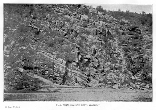
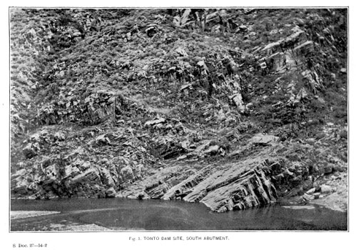
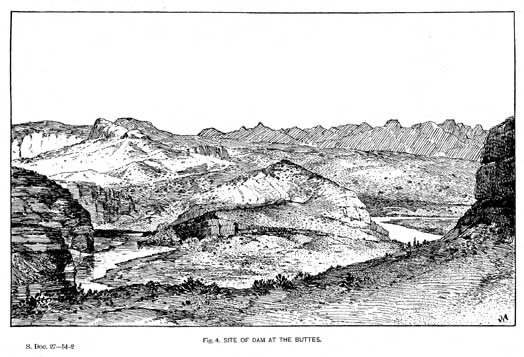


Up: Documents List Previous: Hudson Reservoir and Canal Company Next: Conditions and Cost of Water Storage
© Arizona Board of Regents